How to cite: Guzmán-Speziale, M., 2022, The triple junction of the North America, Cocos, and Caribbean plates. What we know, what we don’t: Revista Mexicana de Ciencias Geológicas, v. 39, núm. 2, p. 190-205.
REVISTA MEXICANA DE CIENCIAS GEOLÓGICAS
v. 39, núm. 2, 2022, p. 190-205
DOI: http://dx.doi.org/10.22201/cgeo.20072902e.2022.2.1666
The triple junction of the North America, Cocos, and Caribbean plates.What we know, what we don’t
Marco Guzmán-Speziale*
Centro de Geociencias, Universidad Nacional Autónoma de México, Blvd. Juriquilla 3001, C.P. 76230, Juriquilla, Qro., Mexico.
*marco@geociencias.unam.mx
ABSTRACT
We present a summary of the tectonic elements of the North America-Caribbean-Cocos triple junction area. In the vicinity of the triple junction, displacement related to the North America-Caribbean plate boundary takes place along the left-lateral Motagua-Polochic fault system, and convergence between the Cocos and the other two plates occurs along the Middle America trench.
The trace of the Motagua-Polochic system is lost at its westernmost end and does not reach the convergent boundary. Deformation of the plate boundary in this location is then distributed along a system of reverse faults (the Reverse-faults tectonic province), a system of left-lateral faults (Strike-slip faults province), two or more large NW-SE oriented left-lateral faults (Angostura and Concordia faults), and a left-lateral fault (Tonalá) that might be construed as the continuation of the Polochic fault along the southern border of the Chiapas Massif.
Somewhere within this deformation zone, transition in overriding plate between North America and Caribbean takes place, but it is not clear exactly where. It is probably at about longitude 96° W because both the dip and the shape of the subducted Cocos slab change significantly at this longitude.
Keywords: Plate tectonics; triple junction; North America plate, Caribbean plate; Cocos plate.
RESUMEN
Presentamos una reseña de los elementos tectónicos que conforman la unión triple de las placas Norte América-Caribe-Cocos. En la cercanía de la unión triple, el desplazamiento relacionado con el límite placas Norte América-Caribe se da a lo largo del sistema de fallas sinistral Motagua-Polochic, mientras que la convergencia entre la placa de Cocos y las otras dos placas se da a lo largo de la trinchera Mesoamericana.
La traza del sistema Motagua-Polochic se pierde en su extremo occidental y no llega a la trinchera. La deformación del límite de placas en este punto se distribuye en un sistema de fallas inversas (la provincia tectónica de fallas inversas), un sistema de fallas laterales de desplazamiento sinistral (la provincia de fallas laterales), dos o más grandes fallas orientadas NW-SE (fallas Angostura y Concordia), y una falla de desplazamiento lateral izquierdo que corre a lo largo del límite sur del macizo de Chiapas (falla Tonalá), la cual pudiera ser interpretada como la continuación de la falla Polochic a lo largo del flanco sur del macizo de Chiapas.
En algún punto de esta zona de deformación tiene lugar la transición en placa superior entre las placas Norte América y Caribe, aunque no está claro dónde exactamente. Es probablemente alrededor de la longitud 96° W, ya que ahí ocurre un cambio significativo en el ángulo de subducción de la placa de Cocos. También en la longitud 96° W se observan cambios en la forma en la trinchera Mesoamericana.
Palabras clave: Tectónica de placas; unión triple; placa de Norte América; placa Caribe; placa de Cocos.
Manuscript received: november 10, 2021
Corrected manuscript received: march 10, 2022
Manuscript accepted: march 11, 2022
INTRODUCTION
The North America, Cocos, and Caribbean plates meet in northern Central America and southern Mexico. The limit between the North America and Caribbean plates is a left-lateral, transform plate boundary, whereas the Cocos plate subducts underneath the North America and Caribbean plates along the convergent margin known as the Middle America trench (MAT) (Figure 1). However, there is no Trench-Trench-Transform Fault (TTF) triple junction, in the classical sense of McKenzie and Morgan (1969), because the three plates do not meet at a single point. The trace of the transform is lost in western Guatemala (e.g., Plafker, 1976; Guzmán-Speziale et al., 1989) and it is not certain where the transition in the overriding plate along the trench is located (e.g., Guzmán-Speziale and Zúñiga, 2016). This has led several authors (e.g., Plafker, 1976; Sykes et al., 1982; Guzmán-Speziale et al., 1989; Guzmán-Speziale and Meneses-Rocha, 2000; Lyon-Caen et al., 2006; Guzmán-Speziale, 2009; Ratschbacher et al., 2009; Authemayou et al., 2011; Franco et al., 2012; Álvarez-Gómez et al., 2019; Ellis et al., 2019; Graham et al., 2021; Garnier et al., 2022) to propose models for the triple junction. In a broader sense, models for the evolution of the Caribbean plate (e.g., Freeland and Dietz, 1971; Burke, 1988; James, 2009; Benthem et al., 2013; García-Reyes and Dymant, 2021) may also be considered models for the triple junction.
Several tectonic features play a role in the deformation of the triple junction. Along the North America-Caribbean plate boundary zone, they are mainly the Motagua, Polochic, and Ixcán fault zones, as well as the Reverse-faults and Strike-slip faults tectonic provinces in southern Mexico. South of these great faults, the grabens of northern Central America also play a role in the tectonics of the area. The Middle America trench and the subducted Cocos Plate are related to the Cocos-Caribbean plate boundary. And finally, another tectonic feature associated to the triple junction is the Central America forearc sliver, located between the Central America volcanic arc and the Middle America trench and the Jalpatagua fault and associated volcanic arc (Figure 1).
In this paper, we review the elements that comprise the triple junction deformation area, and their bearing on the tectonics of the junction. We do so from a neotectonics point of view, that is, we examine the role of different tectonic elements in the present-day tectonics of the triple junction, and not from the perspective of the tectonic evolution through geologic time.
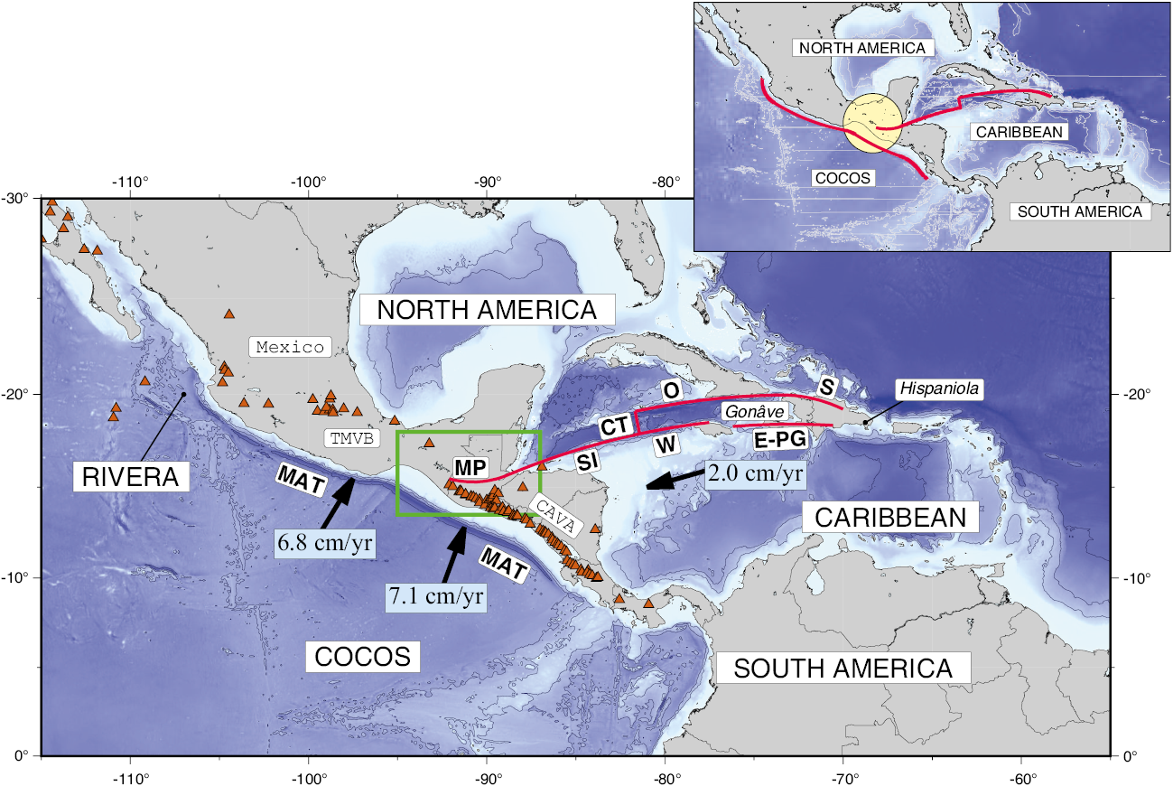
Figure 1. General tectonic framework of the North America-Cocos-Caribbean triple junction area. Names of plates are in upper case lettering. CT – Cayman trough; E-PG - Enriquillo-Plantain Garden fault zone; MAT – Middle America trench; MP – Motagua-Polochic fault zone; O – Oriente fault zone; S – Septentrional fault zone; SI – Swan Island fault zone; W – Walton fault zone. Triangles are volcanoes with historic activity (Siebert et al., 2011; Global Volcanism Program, 2021) of the Central America volcanic arc (CAVA) and the Trans Mexican vocanic belt (TMVB). Relative plate velocities and directions with respect to a fixed North America are indicated (DeMets et al., 2010). Inset highlights the triple junction area. Green rectangle is area depicted in Figure 2. All figures drawn with the help of The Generic Mapping Tools (Wessel and Smith, 1991; Wessel et al., 2013; 2019).
TECTONIC ELEMENTS OF THE TRIPLE JUNCTION AREA
The North America-Caribbean plate boundary zone
The limit between the North America and Caribbean plates is a left-lateral, transform plate boundary that extends from the island of Hispaniola in the east to western Guatemala in the west. It comprises the Enriquillo-Plantain-Garden and Septentrional fault zones in Hispaniola, the Oriente and Walton fault zones southwest of the island of Cuba, and on the eastern part of the Cayman trough. All these faults are left-lateral and define the Gonâve microplate (e.g., Mann et al., 1995; DeMets and Wiggins-Grandison, 2007) (Figure 1). The Cayman spreading center is the western limit of the Gonâve microplate and is located in the middle of the trough. West of the microplate, the Swan Island fault zone flanks the southwest side of the trough, and runs from the spreading center to the coast of Guatemala. Once in continental Guatemala, the Swan Island fault zone becomes the Motagua-Polochic fault zone, a pair of large faults, with subsidiary smaller faults, that run roughly from east to west, concave to the north, while the Swan Island fault is slightly concave to the SSE. These are two left-lateral fault zones that extend for about 350 km, the Polochic to the north, the Motagua to the south (e.g., Bonis, 1967; 1975; Muehlberger and Ritchie, 1975; Burkart, 1978; 1983; Burkart and Self, 1985; Franco et al., 2009; Authemayou et al., 2012; Obrist-Farner et al., 2020) (Figures 1 and 2). Some authors include the Jocotán-Chamelecón fault system, located south of the Motagua fault, as part of the plate boundary zone (e.g., Crane, 1965; Schwartz et al., 1979; Burkart and Self, 1985).
The trace of the Motagua fault is lost underneath Tertiary volcanic deposits in western Guatemala, a few kilometers north-northwest of Guatemala City (e.g., Giunta et al., 2002) (Figure 2a). The Polochic fault abuts against the Chiapas Massif, in the Mexico-Guatemala border (e.g., Guzmán-Speziale et al., 1989) (Figure 2). Apparently, the Polochic fault at its western terminus splays into several branches, that include the Seleguá fault (Dengo, 1968), the Nentón fault (a fault that runs along the Nentón river valley), the San Pedro Necta (Anderson et al., 1973; 1985; Authemayou et al., 2011; Andreani and Gloaguen, 2016) to the northwest, and the Mapastepec fault (Guzmán-Speziale and Meneses-Rocha, 2020) to the southeast (Figure 2b). Neither the Motagua nor the Polochic trace intersects the Middle America trench, so a typical TTF triple junction (McKenzie and Morgan, 1969) has not developed.
Additional to the Motagua and Polochic faults, several authors have proposed other features as part of the North America-Caribbean plate boundary zone. These are (Figure 2): the Ixcán (Guzmán-Speziale, 2010), and Las Conchas (Styron et al., 2020; Guzmán-Speziale and Molina, 2022) faults, north of the Polochic fault zone, and the grabens of northern Central America, a series of N-S trending structures located south of the Motagua fault zone (e.g., Dengo, 1968; Stoiber and Carr, 1973; Muehlberger and Ritchie, 1975; Plafker, 1976; Mann and Burke, 1984; Burkart and Self, 1985; Ferrari et al., 1994; Phipps Morgan et al., 2008; Pérez, 2009).
Tectonic provinces of Chiapas, Mexico
Guzmán-Speziale et al. (1989) and Guzmán-Speziale and Meneses-Rocha (2000, 2020) have suggested that the tectonic provinces of Chiapas, Mexico (Figure 2) are an essential part of the deformation associated to the triple junction. Meneses-Rocha (1985; 2001) identified the following tectonic provinces in Chiapas: The Chiapas batholith, Chicomuselo anticlinorium, Reverse-faults province, Central depression (Sierra homocline), and Strike-slip faults province. Guzmán-Speziale and Meneses-Rocha (2020) include the Tonalá fault zone in this list (Figure 2).
Chiapas batholith
Also called Chiapas massif, it is a mountain chain that runs parallel to the MAT for about 300 km (Figure 2). It is composed mainly of Permo-Triassic granites and granodiorites (Sedlock et al., 1993; Weber et al., 2002, 2008). According to Villagomez and Pindell (2020) the main cooling and exhumation phase took place 40 to 25 Myr ago. Villagomez and Pindell (2020) assigned the massif an important role for the tectonics of the area between 25 and 7 Myr ago. Although very prominent as a topographic feature, the massif does not seem to have any role into the present-day tectonics of the triple junction, aside from being the structure that originates the splaying of the Polochic fault.
Chicomuselo anticlinorium
It is a NW-SE-oriented structure, identified by Burkart (1978; 1983) and Anderson et al. (1985) as the Comalapa anticlinorium (Figure 2a). De La Rosa et al. (1989) identified several anticline and syncline structures within the province, all oriented in a NW-SE to WNW-ESE direction. Location and orientation of the province suggest a transpressive origin within the Concordia fault system (Figure 2a) (see below).
The Reverse-faults province
This province, together with the Strike-slip faults province (see below), forms the Sierra de Chiapas. The Reverse-faults province, located in the eastern Sierra de Chiapas, is a structure shaped as a wide S, mainly concave to the southwest. It consists of a series of narrow, tightly folded anticlines, flanked by reverse faults and whose intervening synclines have been overturned (Meneses-Rocha, 1991, 2001). Guzmán-Speziale and Meneses-Rocha (2000) interpreted this province as a compressive stepover between the left-lateral Motagua-Polochic fault system and the Strike-slip faults province. This province encompasses what was previously known as the Arco de la Libertad (Vinson and Brineman, 1963; De La Rosa et al., 1989), Yaxchilán (Sánchez Montes de Oca, 1979), and Miramar (Sánchez Montes de Oca, 1979; De la Rosa et al., 1989) tectonic provinces.
Strike-slip faults province
This province, located in the northern Sierra the Chiapas, was formerly known as the Mountains of the North and the High Plains tectonic province (Sánchez-Montes de Oca, 1979). It comprises an area of about 360 by 130 km, and is formed by rising and sinking blocks bounded by left-lateral strike-slip faults (Figure 2). The faults range in length from 30 to 165 km (Guzmán-Speziale and Meneses-Rocha, 2020) and have different orientations: variable in the west, NW-SE in the central area, and E-W in the east (Meneses-Rocha, 2001). In all, Guzmán-Speziale and Meneses-Rocha (2020) identified thirteen significant faults within the province overall. Meneses-Rocha (1985) considered an average displacement of 4–5 km (with a maximum of 16 km) along each of the faults, with a total displacement of 70 km along the entire province.
Central Depression
Also called Homoclinal de la Sierra, it is a large plain, 160 km in length and 45 km in width, oriented NW-SE, along which the Grijalva river flows (Figure 2). The Angostura dam and lake are located on this river. The Reverse-faults province is located to the northeast, the Chiapas massif to the south and southeast, and the Strike-slip faults province to the north. The limit between the depression and the Strike-slip faults province is a normal fault (e.g., Meneses-Rocha, 2001), not active at present, as evidenced by the presence of two large alluvial fans along it. The Concordia (also originally a normal fault but presently probably reactivated as a left-lateral, strike-slip fault; Guzmán-Speziale and Menses-Rocha, 2020), is located to the south of this province, marking the limit between the Chiapas massif and the depression (Figure 2) (Movarec, 1983; Burkart et al., 1989; Meneses-Rocha, 2001). The Angostura fault (Figure 2) (Grijalva fault of Graham et al., 2021) runs along the center of the province, in a NW-SE orientation. To the northwest, the depression is crossed by three strike-slip faults, with similar NW-SE orientation: Quintana Roo, Uzpanapa-Las Flores, and La Venta-Grijalva (Figure 2). Based on satellite imagery, Meneses-Rocha (1987) proposed that the Angostura and La Venta-Grijalva are one single structure, more than 200 km long.
Tonalá fault
This fault runs in a NW-SE direction for about 200 km, along the southern flank of the Chiapas massif (Figure 2). It is one of the structures that Muehlberger and Ritchie (1975) identified as a continuation of the Polochic fault. García-Palomares (1978) suggests left-lateral displacement, mainly during the Miocene. Molina-Garza et al. (2015) found indicators of sinistral shearing on Miocene granitoids along the fault, accommodating 100 km of sinistral displacement along the plate boundary in the late Miocene, while Authemayou et al. (2011) considered the fault as one of the main elements (along with the Jalpatagua fault) of their pull-up and zipper model of the triple junction. Graham et al. (2021) see the Tonalá fault as a sub-vertical ductile sinistral transcurrent shear zone, which plays the role of a long-lived North America-Caribbean plate boundary fault.
The Middle America trench
The Middle America trench is the tectonic feature along which the Cocos plate is being subducted underneath the North America and Caribbean plates (Figures 1 and 3) (e.g., Fisher, 1961; Aubouin et al., 1982). The Cocos plate subducts underneath the North America and Caribbean plates along the trench, from the Cocos-Rivera-North America triple junction, at about longitude 104° W, to offshore Nicoya peninsula, Costa Rica (longitude 85° W) (Figure 1). It is still a matter of debate where the transition in overriding plate from North America to Caribbean plate takes place. Guzmán-Speziale and Zúñiga (2016) suggested that it is located at about longitude 96° W along the MAT, because this is where the nature of the trench changes: U-shaped, shallow, with a well-developed accretionary prism to the northwest, and V-shaped, deeper, with almost no accretionary prism to the southeast (Figure 3). Additionally, the subducted slab dips at a shallow angle to the northwest and at a deeper angle to the southeast (Figure 3). All these features are characteristic of what Uyeda (1982) calls a Chilean-type subduction to the northwest, and a Mariana type subduction to the southeast of longitude 96° W. The Cocos plate outboard of the Middle America trench, also shows significant differences on both sides of longitude 96° W. First, this is approximately the site where the Tehuantepec ridge impinges the MAT (Figure 3). Second, ages of the Cocos plate on both sides of the ridge are different: 16 Myr to the northwest, and about 27 Myr to the southeast (Kanjorski, 2003; Manea et al., 2005a, 2005b). Couch and Woodcock (1981) examined free-air gravity data in the gulf of Tehuantepec area, and concluded that the Tehuantepec ridge is a boundary between two different subduction provinces.
The subducted Cocos plate
The Cocos plate is being subducted along the Middle America trench. From the study of its Wadati-Benioff zone (hypocenters of intermediate and deep earthquakes), it has been clear for some time that it does so at different angles northwest and southeast of longitude 96° W (Figure 3) (e.g., Burbach et al., 1984; Bevis and Isacks, 1984; Pardo and Suárez, 1995; Guzmán-Speziale and Zúñiga, 2016, Hayes et al., 2018). The Cocos plate is subducted first at a rather steep angle (about 40° to 45°) underneath the North America plate, next to the plate boundary zone with the Rivera plate (longitude 104° W). The subducted slab then shoals to an almost flat subduction underneath the states of Guerrero and Oaxaca in southern Mexico (longitudes 100° W to 96° W) (Figure 3). The subducted plate then deepens to a subduction angle of some 45°, at the gulf of Tehuantepec region. It continues subducting at roughly the same angle throughout Central America (Figure 3). Some authors (e.g., Pérez-Campos et al., 2008; Dougherty and Clayton, 2014; Castellanos et al., 2018; Carciumaru et al., 2020; Calò, 2021) proposed a tear, and not a smooth bending transition, from shallow to deep subduction, but so far there is no conclusive evidence supporting either a smooth transition or a tear.
The Central America forearc
This is a well-developed continental platform between the Central America volcanic arc (CAVA) and the Middle America trench (Figure 3) (e.g., LaFemina et al., 2009; Álvarez-Gómez et al., 2019). Although the CAVA ends at the Mexico-Guatemala border region, the forearc extends to the northwest, to the gulf of Tehuantepec (Figure 3). Northwest of the gulf, tectonic truncation has prevented the development of a continental platform (e.g., Morán-Zenteno et al., 2018). It has been suggested that the forearc moves to the northwest at a rate of 5 to 16 mm/yr (e.g., DeMets, 2001; Turner et al., 2007; Franco et al., 2012; Ellis et al., 2019; Garnier et al. 2021) either by oblique plate convergence (e.g., DeMets, 2001; Turner et al., 2007; Alvarado et al., 2011) or by indentation of the Cocos ridge (e.g., LaFemina et al., 2009), and along right-lateral faults along the volcanic arc, such as the Jalpatagua fault (Figure 2) (e.g., Wunderman and Rose, 1984; Gordon and Muehlberger, 1994; Authemayou et al., 2011; Garnier, 2020; Garnier et al., 2021), and the El Salvador fault zone (e.g., Dewey et al., 2004; Corti et al., 2005; Staller et al., 2016; Martínez-Díaz et al., 2021), among others.
In either case, the Central American volcanic arc (and its associated faults) would act as a plate boundary zone between the Caribbean plate and the Central America forearc sliver (e.g., Ellis et al., 2019) because the right-lateral faults located along it (e.g., Garnier et al., 2021; Martínez-Díaz et al., 2021) are seismically active. In fact, Lyon-Caen et al. (2006), Franco et al. (2012), and Ellis et al. (2019) consider the forearc a microplate.
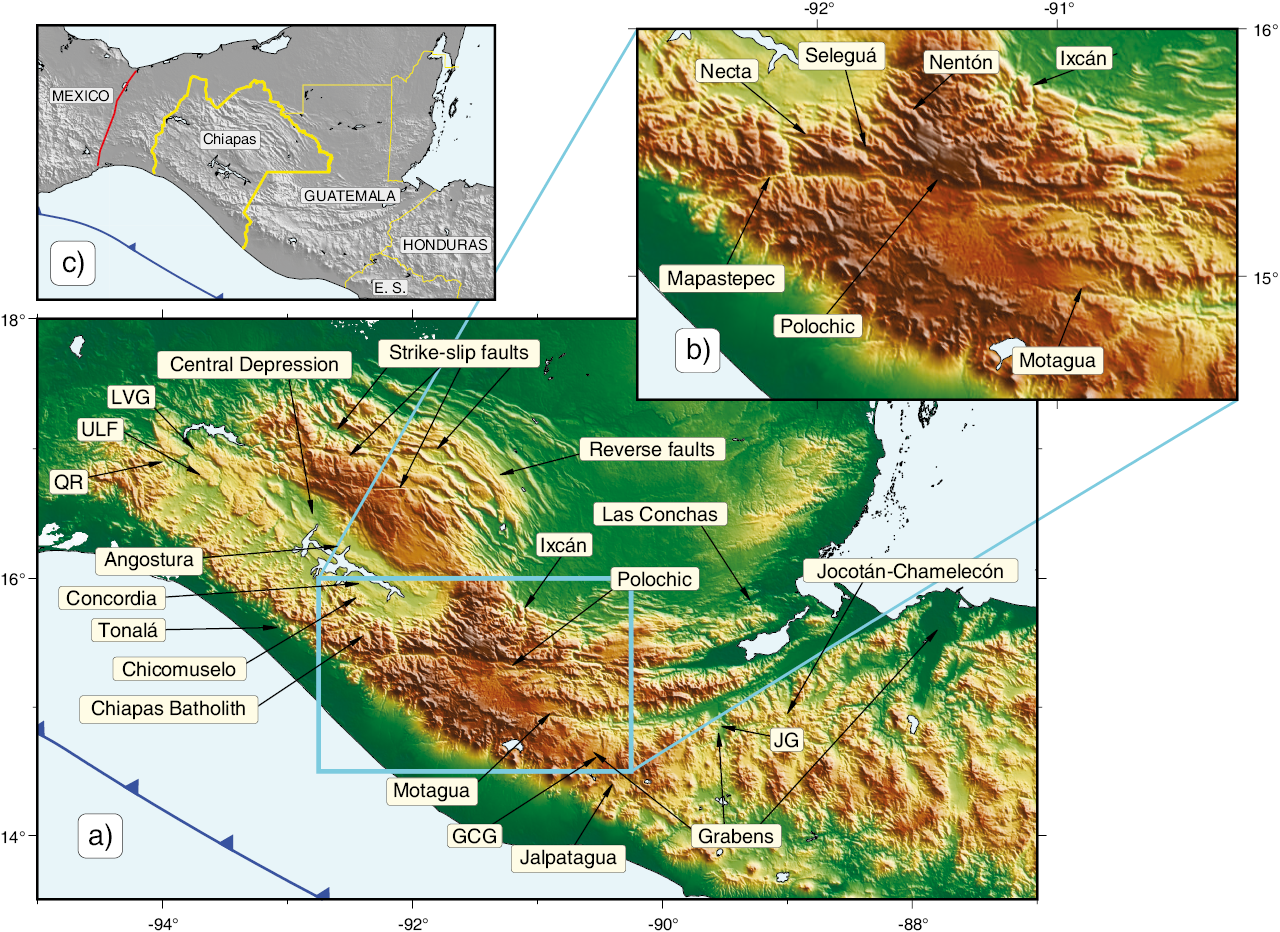
Figure 2. Main active faults of Guatemala and tectonic provinces of Chiapas, Mexico. For clarity, not all faults mentioned in text are named in this figure. a. General map of the region. GCG - Guatemala City graben; JG - Jocotán graben; LVG - La Venta-Grijalva fault; QR - Quintana Roo fault; ULF - Uzpanapa-Las Flores fault. b. Close up around the western end of the Motagua fault. c. Location map of Chiapas, Mexico. The red line is the Isthmus fault.
SEISMICITY
We have gathered hypocentral information from the following catalogs: ISC-EHB (for the years 1964 to 2018) (Weston et al., 2018; Engdahl et al., 2020; International Seismological Centre, 2021) and the United States Geological Survey catalog (2019-2021). Information for historic earthquakes comes from the NGDC/WDS (National Geophysical Data Center) for the years 1523-1963, and the Centennial catalog of Engdahl and Villaseñor (2002), for events in the years 1900 to 1963.
Focal mechanisms were obtained from the Global Centroid-Moment-Tensor (CMT) project (Dziewonski et al., 1981; Ekström et al., 2012). Data are presented in Figures 4, 5, and 6.
The North America-Caribbean plate boundary near the triple junction is seismically active (Figure 4a, 4c). The Swan Island fault zone has been the site of large earthquakes, such as the 4 August 1856 (Magnitude 7 to 8) (Osiecki, 1981; Cox et al., 2008), 28 May, 2009 event (Mw = 7.3) (Graham et al., 2012) or the 10 January, 2018 earthquake (Mw=7.5) (Cheng and Wang, 2020). The Motagua and Polochic faults have experienced several large earthquakes in recent and historic times. The most significant earthquake along the Motagua fault is the one that took place on 4 February, 1976 (e.g., Plafker, 1976; Kanamori and Stewart, 1978; Langer and Bollinger, 1978; Young et al., 1989; White and Harlow, 1993). Three historic earthquakes, in 1538 (M = 6.5 to 7.5; exact date unknown) on 6 January, 1785 (M = 7.3 to 7.5) and on 22 July 1816 (M = 7.5 to 7.7) occurred along the Polochic fault (White, 1984; 1985; Peraldo and Montero, 1999) (Figure 4c). In general, large earthquakes along either the Polochic or Motagua faults are not frequent (e.g., White, 1984). White (1985) examined historic documents and produced an isoseismal map for the 1816 Polcohic earthquake. From the distribution of damaged towns and parishes, it is clear that the event ruptured the central part of the fault. But, at its western end, it seems that the rupture followed the Seleguá and Nentón river valleys, to the northwest of the Polochic fault trace (Figure 2). To the north of the Motagua-Polochic fault system, the Ixcán fault is also seismically active (Guzmán-Speziale, 2010), as is the Las Conchas fault (Figure 4a, 4c). And to the south of Motagua-Polochic, the Jocotán-Chamelecón fault system is not active (Ferrari et al., 1994).
The grabens of northern Central America show seismic activity (Guzmán-Speziale, 2001; Franco et al., 2009) (Figure 4a, 4c). The Guatemala City graben, the westernmost of the series, was activated during the 1976 Motagua earthquake (Langer and Bollinger, 1978). This graben may have also been the site of the earthquake sequence of 1917-1918 which caused severe damages in Guatemala City (Morley, 1918; Saville, 1918; Spinden, 1919); two of the events in the sequence reached magnitudes of more than 6.0 (4 January, 1918, M=6.1; 25 January, 1918, M=6.2) (White and Harlow, 1993). Other grabens are also seismically active (Figure 4a, 4c) (Guzmán-Speziale, 2001), like the Jocotán graben (Franco et al., 2009; Guzmán-Speziale and Molina, 2022). In historic times, there are some events probably related to activity along the grabens, most notably the Santa Marta earthquakes, a series of earthquakes starting on 29 July, 1773 (the day of Saint Martha in the catholic calendar) which forced the relocation of the Captaincy General of Guatemala, from Santiago de los Caballeros (present-day Antigua Guatemala) to Guatemala City.
Seismic activity is also present in some of the tectonic provinces of Chiapas (Figure 4a, 4c). Some earthquakes have occurred in the Reverse-faults province, mainly on its southern end, next to the Ixcan fault (Figure 4a, 4c). The Strike-slip faults province also show some seismic activity (Figure 4a, 4c). Guzmán-Speziale and Meneses-Rocha (2020) found evidence that two large earthquakes may have occurred along one of these faults: 30 March, 1914 (M=7.5) and 5 February, 1954 (M=6.2). Reported depths of these earthquakes in the literature (e.g., Figueroa, 1973; Engdahl and Villaseñor, 2002; NGDC, 2021) exceed 100 km (in which case they would be intraplate earthquakes and not crustal events along the strike-slip faults), but Guzmán-Speziale and Meneses-Rocha (2020) argue that their epicenters are too far from epicenters within the subducted slab. Furthermore, they found newspaper accounts of damages in several towns for the 1954 event, which suggest a shallow source. There are other events in 1545, 1662, and 1878 probably related to activity along these faults (García-Acosta and Suárez-Reynoso, 1996).
Guzmán-Speziale and Meneses-Rocha (2020) argue that the great 23 September, 1902 earthquake (M=7.7) (Böse, 1903; Figueroa, 1970, 1973), along with an earthquake in 1591 (M=7.2) (Peraldo and Montero, 1999), occurred along the Angostura fault. There is another earthquake in the historic record which is probably related to the Angostura fault, in 1743, for which White et al. (2004) assign a similar area of rupture as the 1902 event, and a magnitude of 7.4 to 8.2.
Guzmán-Speziale and Meneses Rocha (2020) report five shallow earthquakes (1912, M=7.0; 1925, M=7.1; 1942, M=6.8; 1943, M=6.0; 1944, M=7.1) (Figure 4c), that might be associated to displacement along the Mapastepec or the Tonalá fault. The 1912 event is also reported in the catalogs we consulted in this work (Engdahl and Villaseñor, 2002; NGDC, 2021), together with two earthquakes, in 1935 (M=7.2) and 1944 (M=7.1) close to the Mapastepec fault. In the original reference (cited by Guzmán-Speziale and Meneses Rocha, 2020) the 1912, 1925, and 1944 events are reported as “shallow” or “crustal”. The depths reported for the 1942 and 1943 in the original sources, are 70 and 60 km, respectively.
The other two tectonic provinces of Chiapas, the Batholith and the Chicomuselo anticline, do not appear to be seismically active (Figure 4a, 4c). On the other hand, it is interesting to note that crustal seismicity west of longitude 96° W is practically non-existent (Figure 4a).
The convergent margin between the Cocos and the two other plates is seismically active: Interplate earthquakes occur and a well-defined Wadati-Benioff zone is present. However, the area around longitude 96° W marks a significant change in seismic regime, once again in agreement with the two subduction types of Uyeda (1982): to the northwest, large interplate earthquakes take place (Figure 4a, 4c), whereas to the southeast there is a well-documented seismic gap that spans from the gulf of Tehuantepec to the Mexico-Guatemala border region, and going back at least 200 years (Singh et al., 1981; Suárez, 2021). The largest documented earthquake in Mexico (M=8.6, 28 March, 1787; Suárez and Albini, 2009) was probably an interplate event that occurred just northwest of Tehuantepec ridge, along the proposed Chilean-type regime, that even caused a tsunami. The change in seismicity also takes place within the subducted slab: to the northwest, hypocenters are not deeper than 100 km, whereas to the southeast, earthquake depths can reach 250–270 km (Figure 4b) (e.g., Guzmán-Speziale and Zúñiga, 2016).
Focal mechanisms from the Global Centroid-Moment-Tensor (CMT) Project (Dziewonski et al., 1981; Ekström et al., 2012) are in good agreement with their respective tectonic features (Figures 5 and 6). According to the data, faulting is left-lateral, strike-slip along the North America-Caribbean plate boundary, Swan, Motagua, and Polochic fault zones (Figure 5). Right-lateral mechanisms are found along the Jalpatagua fault and faults in El Salvador (CAVA) (Figure 5). Other strike-slip mechanisms for shallow events (z ≤ 50 km) are found in the gulf of Tehuantepec area, which are probably related to the Isthmus fault (Barrier et al., 1998) (Figure 2). West of 96° W, strike-slip mechanisms for shallow (z ≤ 50 km) earthquakes probably correspond to activity along the Chacalapa (or La Venta-Chacalapa) fault zone (Gaidzik et al., 2016; Kazachkina et al., 2019; 2020) (Figure 5).
Thrust-faulting mechanisms for shallow events (z ≤ 50 km) show the expected interplate activity along the Cocos convergent margin (Figure 5b). Additionally, three such mechanisms are found at the southern end of the Reverse-faults province (Figure 5b). Crustal, normal-faulting activity is clearly present along the grabens of northern Central America, mostly with fault planes oriented in a general N-S direction (Figure 5c). Other shallow, normal-faulting solutions are found associated with initial bending of the Cocos plate, a common feature along subduction zones (e.g., Astiz et al., 1988; Beck and Ruff, 1989) (Figure 5c). However, earthquakes of this type are not present west of longitude 96° W, probably as a consequence of the difference in the type of subduction (Uyeda, 1982). There are, on the other hand, shallow, normal-faulting events in the gulf of Tehuantepec and on land that deserve a closer investigation (Figure 5c). Strike-slip focal mechanisms for earthquakes deeper than 50 km show two areas of interest: offshore Guatemala and the Isthmus of Tehuantepec (Figure 6a), probably associated to bending of the subducted Cocos plate (e.g., Pérez-Campos et al., 2008). The rest of the focal mechanisms, thrust- and normal-faulting (Figure 6), display the usual seismic activity related to the subducted slab (e.g., Burbach et al., 1984; Guzmán-Speziale and Zúñiga, 2016).
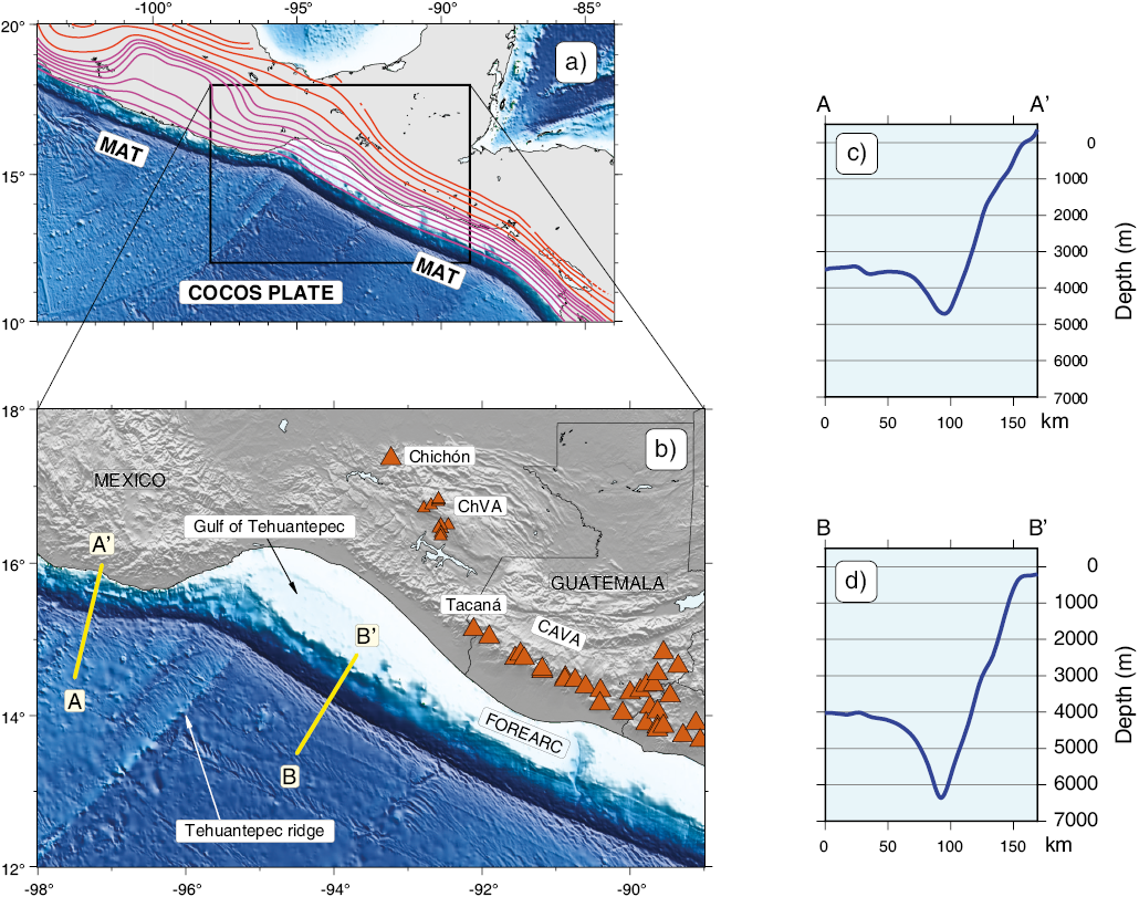
Figure 3. The subducted Cocos plate and the Middle America trench. a) Curves of equal depth, according to model Slab2 of Hayes et al. (2018). Magenta curves every 10 km, from 20 to 80 km. Orange curves every 50 km, from 100 to 300 km. MAT- Middle America trench. b) Zoom of the gulf of Tehuantepec area. Location of sections A-A’ and B-B’ (perpendicular to the Middle America trench) is shown. Triangles are volcanoes of the Central America volcanic arc. c) Section A-A’. d) Section B-B’.
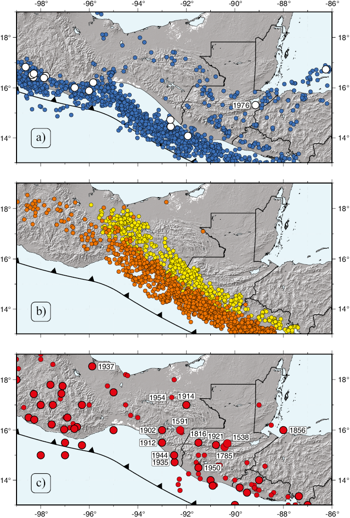
Figure 4. Seismicity in the triple junction area. a. Shallow (z ≤ 50 km) earthquakes in the years 1964-2021. Larger, white symbols are events with magnitudes 7.0 or greater. b. Intermediate-depth (50 < z ≤ 100 km) (orange) and deep (z > 100 km) (yellow) events, in the years 1964-2021. c. Historic (1523-1963) earthquakes. Larger symbols are events with magnitude 7.0 or greater. Events with a label for year are those reported as having a crustal depth. (See text for details).
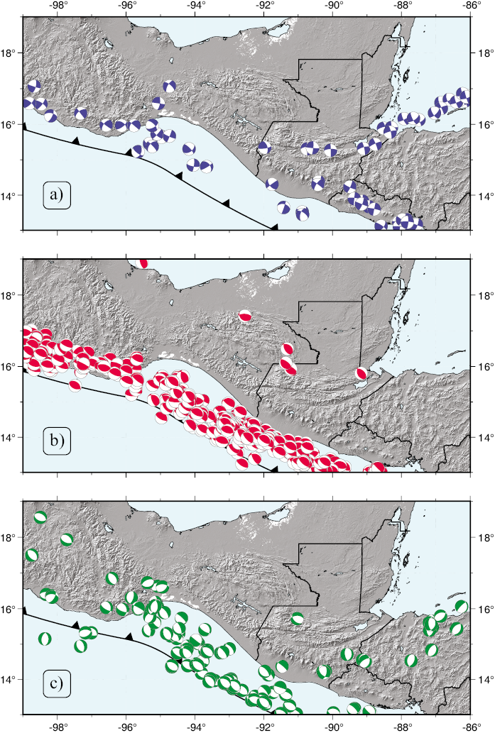
Figure 5. Focal mechanisms for shallow (z ≤ 50 km) earthquakes, as reported by the Global Centroid-Moment-Tensor (CMT) Project, 1976 - 2021 (Dziewonski et al., 1981; Ekström et al., 2012). a) Strike-slip events (plunge of B-axis ≥ 45°); b) Thrust-faulting earthquakes (plunge of T-axis ≥ 45°); c. Normal faulting events (plunge of P-axis ≥ 45°).
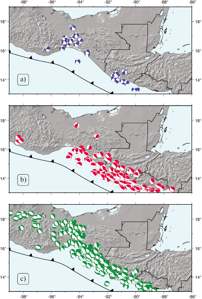
Figure 6. Focal mechanisms for intermediate-depth and deep (z > 50 km) earthquakes, as reported by the Global Centroid-Moment-Tensor (CMT) Project, 1976 - 2021 (Dziewonski et al., 1981; Ekström et al., 2012). a) Strike-slip events (plunge of B-axis ≥ 45°); b) Thrust-faulting earthquakes (plunge of T-axis ≥ 45°); c) Normal faulting events (plunge of P-axis ≥ 45°).
VOLCANISM
The Central America Volcanic Arc (CAVA) is a chain of active volcanoes in Central America, parallel to the Middle America trench (Figure 1). It consists of about 75 closely spaced basaltic to dacitic volcanoes, with documented Pleistocene or Holocene activity (e.g., Global Volcanism Program, 2013). The northwesternmost volcano of this chain is Tacaná, in the Mexico-Guatemala border region (Figure 3b). To the northwest, the only active volcano between the CAVA and Trans-Mexican Volcanic belt (TMVB) is El Chichón (also called Chichonal), whose acticity spans from Pleistocene to recent (Figure 3b) (e.g., Damon and Montesinos, 1978; Macias, 2005; Scolamacchia and Capra, 2015).
Between the Tacaná and Chichón volcanoes, there is a volcanic area called the Chiapanecan Volcanic Arc, which consists of a 150-km long chain of about ten volcanic structures aligned NW-SE, and active during the Pleistocene (e.g., Damon and Montesinos, 1978; Manea and Manea, 2006; Mora et al., 2007; 2012) (Figure 3b). No large stratovolcanoes were developed, contrary to what happens to the southeast along the CAVA, or to the north-northwest along the Trans-Mexican Volcanic belt (TMVB) (Figure 1). Even considering the Chiapanecan arc, there is a substantial gap in recent and present-day volcanic activity in Chiapas.
The Trans-Mexican Volcanic Belt (TMVB) extends for about 1000 to 1200 km, in an E-W orientation, overlying the subducted Rivera and Cocos plates (Figure 1). It is a volcanic belt of predominantly andesitic and dacitic rocks, spanning from middle Miocene to Holocene (Mooser, 1972; Nixon, 1982; Urrutia-Fucugauchi and Böhnel, 1988; Ferrari et al., 2012, Verma et al., 2020). Los Tuxtlas volcanic field (e.g., Robin and Tournon, 1978; Nelson et al., 1995; Ferrari et al., 2005) is the easternmost area of the TMVB. It differs from the rest of the volcanic arc in that it is an alkaline mafic volcanic field (Nelson et al., 1995, Verma et al., 2020), as opposed to the andesitic-dacitic TMVB.
KINEMATICS OF THE REGION, BASED ON GPS
Most GPS sites in the triple junction area are located in Central America (Lyon-Caen et al., 2006; Turner et al., 2007; Correa-Mora et al., 2009; Rodriguez et al., 2009; Franco et al., 2012; Álvarez-Gómez et al., 2019; Ellis et al., 2019; Garnier et al., 2021). Lyon-Caen et al. (2006) used GPS measurements across the Polochic-Motagua fault system and found a far-field displacement of about 20 mm/yr, in good agreement with modern plate velocity models (DeMets et al., 2010). In the near field, they found that the slip rate along the Motagua fault decreases from east to west, from 20 mm/yr to 12 mm/yr. This 8 mm/yr deficit, they argue, is accommodated by extension along the grabens of northern Central America (e.g., Guzmán-Speziale, 2001). They also found ~10 mm/yr of dextral slip along the Jalpatagua fault. Rodríguez et al. (2009), found west to west-northwest displacement in Honduras and southern Guatemala, at an increasing rate (from east to west) from 3.3, to 4.1, to 11–12 mm/yr, which they interpret as motion along the grabens of northern Central America. Differential coupling along the Cocos-Caribbean plate boundary was found by Correa-Mora et al. (2009) along the convergent boundary of El Salvador and Nicaragua. Turner et al. (2007), using campaign sites, determined a northwest translation of the forearc offshore Nicaragua of about 15 mm/yr. Franco et al. (2012) find a predominance of the Motagua fault over the Polochic in the deformation of the North America-Caribbean plate boundary. Again, they find an east-west decrease in the GPS-calculated displacement, from 18–22 mm/yr in eastern Guatemala, to 14–20 mm/yr in the center of the country, to “a few millimiters” in western Guatemala which, they suggest, means that the northwest corner of the Caribbean plate deforms internally at a rate of 9 mm/yr,with 5 mm/yr of this being taken up along the Guatemala City graben alone. According to these authors, displacement along the Jalpatagua and El Salvador faults is in the order of 15 mm/yr. Finally, they found lateral variations of coupling along the MAT convergent boundary. High coupling takes place northwest of the Tacaná volcano and low coupling to the southeast. Finally, Ellis et al. (2019) find that 80 % of displacement along the Motagua-Polochic fault system takes place along the former and 20 % along the latter. As previous authors, they find a westward decrease of slip rate, from 14 mm/yr in eastern Guatemala, to 9–10 mm/yr in central Guatemala, and less than 2 mm/yr in western Guatemala, west of the Guatemala City graben. They also find 13 mm/yr of east-west stretching along the grabens of northern Central America. Slip rates along the CAVA show a southeast-northwest decrease, from 12.5 mm/yr in Nicaragua, 10 mm/yr along the El Salvador fault system, and 7.6 mm/yr along the Jalpatagua fault in Guatemala. A change in locking along the MAT convergent boundary (moderate to high offshore southern Mexico, low offshore Guatemala) is also suggested in this study.
DISCUSSION
It is clear that the North America-Cocos-Caribbean triple junction is not a simple meeting point on the surface of the Earth, but rather an area of distributed deformation, located throughout Guatemala, the state of Chiapas, Mexico, and the Central America forearc. Even the Middle America trench shows evidence of differences at longitude 96° W, possibly related to deformation of the triple junction.
At the western terminus of the North America-Caribbean plate boundary zone there is no surface trace of the Motagua fault that would intersect the Middle America trench. In older works, authors used to depict the triple junction as a simple trench-trench-transform point (e.g., Plafker, 1976; Burkart and Self, 1985). To date, however, there is no evidence, direct or indirect, that the Motagua fault continues to the west of its known surface trace, underneath the Tertiary volcanic cover, or offshore and into the gulf of Tehuantepec (e.g., Sánchez-Barreda, 1981. The rupture process of the great 4 February, 1976 earthquake along the Motagua fault ruptured a 230-km-long segment of the fault, with a left-lateral displacement. But once displacement reached the western terminus of the fault, rupture continued perpendicular to the fault trace, along the Guatemala City graben, and as normal faults (Langer and Bollinger, 1978). Langer and Bollinger (1978) and Guzmán-Speziale et al. (1989) interpret this as evidence that the Motagua fault ends at its westernmost known surface.
The Polochic fault abuts against the Chiapas massif, at the Mexico-Guatemala border region, but it can be argued that its trace splays into two main segments, surrounding the Chiapas batholith (e.g., Muehlberger and Ritchie, 1975; Guzmán-Speziale and Meneses-Rocha, 2020), the northern segment along the short (70–80 km long) Guerrero (San Pedro Necta) fault, and the southern segment into the Mapastepec and Tonalá faults. The northern segment has no known seismic activity, while evidence for present-day displacement along the strike-slip Tonalá or Mapastepec faults is not firm. Some or all of the documented earthquakes that could be ascribed to either fault, spanning from 1912 to 1944 (Guzmán-Speziale and Meneses-Rocha, 2020) (see above), might be related to the subduction process, given the proximity to seismic sources of inter- and intraplate nature and the lack of accuracy in depth determination.
There is no firm indication that historic earthquakes along the Angostura fault did occur along this fault. According to the epicentral location, it is possible that these earthquakes could have originated within the subducted slab. The 1902 earthquake is probably the only historic event with enough evidence, in the form of isoseismal maps (Böse, 1903; Figueroa, 1973), that could correspond to faulting along the Angostura fault, although for Suárez (2021) this is a subduction event.
Seismicity along the Strike-slip faults province, on the other hand, is most probably of a crustal nature, because epicenters, although sometimes reported as deep, are far away from those related to subduction. By the same argument, seismicity along the Reverse-faults province must also be crustal.
Very conspicuous changes in the morphology of the MAT occur in the area of the gulf of Tehuantepec, at about longitude 96° W. These changes also correspond to changes in the dip of subduction of the Cocos plate and also to changes in the Cocos plate outboard of the trench. One possibility for these changes is the transition in overriding plate, from North America to the northwest, to Caribbean in the southeast (e.g., Guzmán-Speziale and Zúñiga, 2016). But it is also possible that the change in subduction geometry is a consequence of the presence and subduction of the Tehuantepc ridge, as has been proposed by Suárez (2000).
It has been suggested that the Central America forearc sliver acts as an independent platelet, moving to the northwest at 5 to 16 mm/yr (e.g., Lyon-Caen et al., 2006; LaFemina et al., 2009; Franco et al., 2012; Álvarez-Gómez et al., 2019; Ellis et al., 2019; Garnier et al., 2021). This conclusion comes essentially from GPS measurements in Central America. But the sliver as a physiographic entity, is continuous from offshore Costa Rica to the gulf of Tehuantepec (Figures 1 and 7). A contradiction arises from the fact that along the CAVA, documented motion, from earthquake focal mechanisms (e.g., Guzmán-Speziale et al., 2005) and GPS (Lyon-Caën et al., 2006; Franco et al., 2012; Álvarez-Gómez et al., 2019; Ellis et al., 2019; Garnier et al., 2021) is right-lateral, while the northernmost forearc offshore southern Mexico, is flanked by the Tonalá fault, a left-lateral structure (García-Palomares, 1978; Authemayou et al., 2012; Molina-Garza et al., 2015). To complicate matters further, Kazachkina et al. (2019; 2020) suggest the presence of a Xolapa sliver, located northwest of the Central America forearc, parallel to the Middle America trench, and being displaced to the southeast along the 650-km long Chacalapa fault at a rate of 5.6 to 10 mm/yr (Kazachkina et al., 2019; 2020) (Figure 7). The role of these two forearc sliver in the tectonics of the triple junction is still an open question.
GPS results show that relative motion along both the Motagua and Polochic faults gradually decrease from east to west, which suggests that, indeed, the westernmost end of both faults are both locked to some extent and accumulating strain. Most of the deformation is being accommodated by the Motagua fault. The decreasing slip rates from east to west and the western termination of the faults could imply that the left-lateral motions are being transferred into other structures, such as the Reverse faults, the Strike-slip faults and even the Tonalá fault.
Figure 7 shows a summary of observed deformation in the triple junction area: left-lateral, strike-slip faulting along several of the fault systems, like the Motagua, Polochic and related faults (like the Ixcán), the Angostura fault area, Strike-slip faults province, and Tonalá fault; right-lateral faulting along the Jalpatagua fault; compression along the Reverse-faults province; extension in the grabens of northern Central America; northwest transport of the Central America forearc sliver; Southwest displacement of the Xolapa forearc. And finally, changes in the Cocos plate at longitude 96° W, both outboard of the Middle America trench and within the subducted slab.
Questions remain to be answered:
- How is strain transferred from the left-lateral Motagua and Polochic faults to the Reverse faults and Strike-slip faults in southern Mexico? Guzmán-Speziale and Meneses-Rocha (2000) suggest that this happens as a fault step, but the actual mechanism of the step remains to be explained.
- How is strain transferred west of the Reverse- and Strike-slip faults provinces? Large deformation associated to the North America-Caribbean plate boundary must be expressed somewhere but, the only apparent large structure is the Isthmus fault.
- Is the Isthmus fault active at present? Is it related to the triple junction?
- What is the role of the grabens of northern Central America? It is known that the grabens are part of a system of east-west extensive structures that extend from Jamaica to Guatemala (e.g., Mann and Burke, 1984), but, why does the extensive regime stops at the Guatemala City graben?
- The dip of the subducted Cocos plate changes at longitude 96° W. Is this change related to the triple junction?
- Is the Central America forearc a separate platelet?
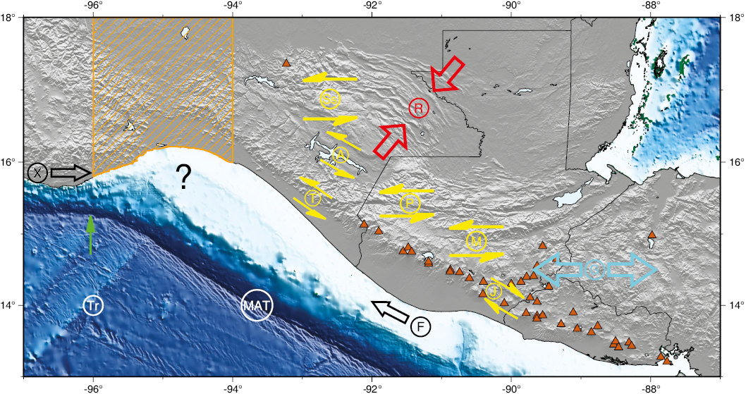
Figure 7. Summary map of deformation in the triple junction area. Strike-slip faulting in yellow: A.- Angostura and Central Depression faults; J.- Jalpatagua fault; M.- Motagua fault; P.- Polochic fault; Ss.- Strike-slip faults province; T.- Tonalá fault. Extensional region in cyan: G.- Grabens of northern Central America; Compressional region in red: R.- Reverse-faults province. Forearcs in black: F.- Central America forearc sliver; X.- Xolapa forearc; arrows show direction of proposed slip. Other features: MAT.- Middle America Trench; Tr.- Tehuantepec ridge. Hachured pattern shows approximate region where change in dip of subduction takes place. Green arrow indicates approximately where characteristics in trench change. Question mark indicates an area of uncertain tectonic regime.
CONCLUSIONS
The North America-Cocos-Caribbean plates triple junction is not a single point, but rather a zone of deformation encompassing the Motagua-Polochic fault system, the grabens of nortern Central America, Chiapas, Mexico, and the Central America forearc.
The North America-Caribbean plate boundary zone is defined by a system of transform faults, from the northeastern Caribbean to western Guatemala. Deformation of this plate boundary extends to the Reverse faults, Strike-slip faults, and Tonalá fault in southern Mexico, and to the grabens of northern Central America in Guatemala
The plate boundary between the Cocos and the other two plates is a convergent one, in which Cocos subducts underneath the other two along the Middle America trench. It is not clear where the transition in overriding plate from North America to Caribbean occurs. Significant changes take place along the Middle America trench in the gulf of Tehuantepec area. These changes are probably related to transition from North America to Caribbean plates. Finally, it is not clear what the role of the Central America and Xolapa forearc slivers is.
ACKNOWLEDGMENTS
I am grateful to two anonymous reviewers who meticulously read the manuscript and made very valuable comments which greatly improved it. This review reflects my long-time interest in the subject of the triple junction, starting with my Master’s thesis at the University of Texas at Austin, a number of years ago. Throughout the years, many people have contributed to improve my knowledge of the subject. A non-exhaustive list includes my coauthors in several papers Toshi Matsumoto, Wayne Pennington, Ramón Zúñiga, Juan Martín Gómez, Enrique Molina, and very specially Javier Meneses-Rocha. All figures drawn with the help of The Generic Mapping Tools (Wessel and Smith, 1991; Wessel et al., 2013; 2019). This is Centro de Geociencias contribution 1927.
REFERENCES
Alvarado, D., DeMets, C., Tikoff, B., Hernández, D., Wawrzyniec, T.F., Pullinger, C., Mattioli, G., Turner, H.L., Rodríguez, M., Correa-Mora, F., 2011, Forearc motion and deformation between El Salvador and Nicaragua: GPS, seismic, structural, and paleomagnetic observations: Lithosphere, 3, 3-21, https://doi.org/10.1130/L108.1
Álvarez-Gómez, J.A., Vázquez, A.S., Martínez-Díaz, J.J., Canora, C., Alonso-Henar, J., Insua-Arévalo, J.M., Béjar-Pizarro, M., 2019, Push-pull driving of the Central America Forearc in the context of the Cocos-Caribbean-North America triple junction: Scientific Reports, 9, 1-13, https://doi.org/10.1038/s41598-019-47617-3
Anderson, T.H., Burkart, B., Clemons, R.E., Bohnenberger, O.H., Blount, D.N., 1973, Geology of the western Altos Cuchumatanes, northwestern Guatemala: Geological Society of America Bulletin, 84, 805-826.
Anderson, T.H., Erdlac, R.J., Sandstrom, M.A., 1985, Late-Cretaceous allochthons and post-Cretaceous strike-slip displacement along the Cuilco-Chixoy-Polochic fault, Guatemala: Tectonics, 4, 453-475, https://doi.org/10.1029/TC004i005p00453
Andreani, L., Gloaguen, R., 2016, Geomorphic analysis of transient landscapes in the Sierra Madre de Chiapas and Maya Mountains (northern Central America): implications for the North American–Caribbean–Cocos plate boundary: Earth Surface Dynamics, 4, 71-102, https://doi.org/10.5194/esurf-4-71-2016
Astiz, L., Lay, T., Kanamori, H., 1988, Large intermediate-depth earthquakes and the subduction process: Physics of the Earth and Planetary Interiors, 53, 80-166, https://doi.org/10.1016/0031-9201(88)90138-0
Aubouin, J., Azema, J., Carfantan, J.C., Demant, A., Rangin, C., Tardy, M., Tournon, J., 1982, 41. The Middle America trench in the geological framework of Central America: Deep Sea Drilling Project Reports and Publications, LXVII, 747-755, doi:10.2973/dsdp.proc.67.141.1982
Authemayou, C., G. Brocard, C. Teyssier, Simon-Labric, T., Gutiérrez, A., Chiquín, E. N., Morán, S., 2011, The Caribbean-North America-Cocos triple junction and the dynamics of the Polochic-Motagua fault systems: Pull-up and zipper models: Tectonics, 30, TC3010, doi:10.1029/2010TC002814
Authemayou, C., Brocard G., Teyssier C., Suski B., Cosenza B., Morán-Ical S., González-Véliz C.W., Aguilar-Hengstenberg M.A., Holliger K., 2012, Quaternary seismo-tectonic activity of the Polochic Fault, Guatemala: Journal of Geophysical Research, 117, B07403, doi:10.1029/2012JB009444
Barrier, E., Velasquillo, L., Chavez, M., Gaulon, R., 1998, Neotectonic evolution of the Isthmus of Tehuantepec (southeastern Mexico): Tectonophysics, 287, 77-96, https://doi.org/10.1016/S0040-1951(98)80062-0
Beck, S. L., Ruff, L.J., 1989, Great earthquakes and subduction along the Peru trench: Physics of the Earth and Planetary Interiors, 57, 199-224, https://doi.org/10.1016/0031-9201(89)90112-X
Benthem, S., Govers, R., Spakman, W., Wortel, R., 2013, Tectonic evolution and mantle structure of the Caribbean: Journal of Geophysical Research, 118, 3019-3036, doi:10.1002/jgrb.50235
Bevis, M. Isacks, B.L., 1984, Hypocentral trend surface analysis: Probing the geometry of Benioff Zones: Journal of Geophysical Research, 89, 6153-6170, https://doi.org/10.1029/JB089iB07p06153
Bonis, S., 1967, Geologic Reconnaissance of the Alta Verapaz Fold Belt, Guatemala: Louisiana, USA, Louisiana State University, Ph.D. dissertation, 181 pp.
Bonis, S.B., 1975, Guatemala, in World Regional Geology, Encyclopedia of Earth Science: Springer Dordrecht, 305-309.
Böse, E., 1903, Informe sobre los Temblores de Zanatepec a Fines de Septiembre de 1902 y sobre el Estado Actual del Volcán de Tacaná: Parergones del Instituto Geológico de México, 1, 25 pp.
Burbach, G.V., Frohlich, C., Pennington, W.D., Matumoto, T., 1984, Seismicity and tectonics of the subducted Cocos Plate: Journal of Geophysical Research, 89, 7719-7735, https://doi-org.pbidi.unam.mx:2443/10.1029/JB089iB09p07719
Burkart, B., 1978, Offset across the Polochic fault of Guatemala and Chiapas, Mexico: Geology, 6, 328-332, https://doi.org/10.1130/0091-7613(1978)6<328:OATPFO>2.0.CO;2
Burkart, B., 1983, Neogene North American-Caribbean plate boundary across northern Central America: Offset along the Polochic fault: Tectonophysics, 99, 251-270.
Burkart, B., Self, S., 1985, Extension and rotation of crustal blocks in northern Central America and effect on the volcanic arc: Geology, 13, 22-26.
Burkart, B., Blair T.C., Movarec, D., 1989, Late Cretaceous blockarc deposits of Chiapas, Mexico, and their relation to the orogen: Geological Society of America Abstracts with programs, 21, 5.
Burke, K., 1988, Tectonic Evolution of the Caribbean: Annual Review of Earth and Planetary Sciences, 16, 201-230, https://doi.org/10.1146/annurev.ea.16.050188.001221
Calò, M., 2021, Tears, windows, and signature of transform margins on slabs. Images of the Cocos plate fragmentation beneath the Tehuantepec isthmus (Mexico) using Enhanced Seismic Models: Earth and Planetary Science Letters, 560, 116788, https://doi.org/10.1016/j.epsl.2021.116788
Carciumaru, D., Ortega, R., Castillo Castellanos, J., Huesca-Pérez, E., 2020, Crustal Characteristics in the Subduction Zone of Mexico: Implication of the Tectonostratigraphic Terranes on Slab Tearing: Seismological Research Letters, 91, 1781-1793, doi: 10.1785/0220190117
Castellanos, J.C., Clayton, R.W., Pérez-Campos, X., 2018, Imaging the eastern Trans-Mexican Volcanic Belt with ambient seismic noise: Evidence for a slab tear: Journal of Geophysical Research: Solid Earth, 123, 7741-7759, https://doi.org/10.1029/2018JB015783
Cheng, C., Wang, D., 2020, Imaging the rupture process of the 10 January 2018 M W 7.5 Swan island, Honduras earthquake: Earthquake Science, 33, 194-200, doi: 10.29382/eqs-2019-0000-00
Correa-Mora, F., DeMets, C., Alvarado, D., Turner, H. L., Mattioli, G., Hernández, D., Pullinger, C., Rodríguez, M., Tenorio, C., 2009, GPS-derived coupling estimates for the Central America subduction zone and volcanic arc faults: El Salvador, Honduras and Nicaragua: Geophysical Journal International, 179, 1279-1291, https://doi.org/10.1111/j.1365-246X.2009.04371.x
Corti, G., Carminati, Mazzarini, F., García, M. O., 2005, Active strike-slip faulting in El Salvador, Central America: Geology, 33, 989-992, https://doi.org/10.1130/G21992.1
Couch, R., Woodcock, S, 1981, Gravity and Structure of the Continental Margins of Southwestern Mexico and Northwestern Guatemala: Journal of Geophysical Research, 86, 1829-1840, https://doi.org/10.1029/JB086iB03p01829
Cox, R.T., Lumsden, D.N., Gough, K., Lloyd, R., Talnagi, J., 2008, Investigation of late Quaternary fault block uplift along the Motagua/Swan Islands fault system: Implications for seismic/tsunami hazard for the Bay of Honduras: Tectonophysics, 457, 30-41, https://doi.org/10.1016/j.tecto.2008.05.014
Crane, D.C., 1965, Geology of the Jocotán and Timushán qudrangles, southeastern Guatemala: Houston, Texas, Rice University, USA Ph. D. dissertation, 85 pp.
Damon, P., Montesinos, E., 1978, Late Cenozoic volcanism and metallogenesis over an active Benioff Zone in Chiapas, México: Arizona Geological Society Digest, 11, 155-168.
De la Rosa, J.L., Eboli, A., Dávila, M., 1989, Geología del Estado de Chiapas: Chiapas, México, Comisión Federal de Electricidad, Tuxtla Gutiérrez, 192 pp.
DeMets, C., 2001, A new estimate for present-day Cocos-Caribbean Plate motion: Implications for slip along the Central American Volcanic Arc: Geophysical Research Letters, 21, 4043-4046, https://doi.org/10.1029/2001GL013518
DeMets, C. Wiggins-Grandison, M., 2007, Deformation of Jamaica and motion of the Gonâve microplate from GPS and seismic data: Geophysical Journal International 168, 362-378, doi: 10.1111/j.1365-246X.2006.03236.x
DeMets, C., Gordon, R.G., Argus, D.F., 2010, Geologically current plate motions: Geophysical Journal International, 181, 1-80, https://doi.org/10.1111/j.1365-246X.2009.04491.x
Dengo, G., 1968, Estructura Geológica, Historia tectónica y Morfología de América Central: Mexico City, Mexico, Centro Regional de Ayuda Técnica, Agencia para el Desarrollo Internacional, 51 pp.
Dewey, J.W., White, R.A., Hernández, D.A., 2004, Seismicity and tectonics of El Salvador, in Rose, W.I., Bommer, J.J., López, D.L., Carr, M.J., Major, J.J. (eds.), Natural hazards in El Salvador: Boulder, Colorado, Geological Society of America Special Paper, 375, 363-378.
Dougherty, S.L., Clayton, R.W., 2014, Seismicity and structure in central Mexico: Evidence for a possible slab tear in the South Cocos plate: Journal of Geophysical Research: Solid Earth, 119, 3424–3447, doi:10.1002/2013JB010883
Dziewonski, A.M., Chou, T.-A., Woodhouse, J.H., 1981, Determination of earthquake source parameters from waveform data for studies of global and regional seismicity: Journal of Geophysical Research, 86, 2825-2852, https://doi.org/10.1029/JB086iB04p02825
Ekström, G., Nettles, M., Dziewonski, A.M., 2012, The global CMT project 2004-2010: Centroid-moment tensors for 13,017 earthquakes: Physics of the Earth and Planetary Interiors, 200-201, 1-9, https://doi.org/10.1016/j.pepi.2012.04.002
Ellis, A., DeMets, C., McCaffrey, R., Briole, P., Cosenza Muralles, B., Flores, O., Guzmán-Speziale, M., Hernández, D., Kostoglodov, V., LaFemina, P., Lord, N., Lasserre, C., Lyon-Caen, H., Rodríguez Madariaga, M., Molina, E., Rivera, J., Rogers, R., Staller, A., 2019, GPS constraints on deformation in northern Central America from 1999 to 2017, Part 2: Block rotations and fault slip rates, fault locking and distributed deformation: Geophysical Journal International, 218, 729-754, https://doi.org/10.1093/gji/ggz173
Engdahl, E.R., Villaseñor, A., 2002, Global Seismicity: 1900–1999: International Handbook of Earthquake and Engineering Seismology, 81a: Amsterdam, Elsevier Science Ltd., 665-690.
Engdahl, E.R., Di Giacomo, D., Sakarya, B., Gkarlaouni, C.G., Harris, J., Storchak, D.A., 2020, ISC-EHB 1964-2016, an Improved Data Set for Studies of Earth Structure and Global Seismicity: Earth and Space Science, 7(1), e2019EA000897, https://doi.org/10.1029/2019EA000897
Ferrari, L., Pasquare, G., Zilioli, E., 1994, Kinematics and seismotectonics of a segment of the North America-Caribbean plate boundary: a remote sensing and field study of the Jocotan fault system in Guatemala in Satellite Remote Sensing: Rome, Italy, SPIE Proceedings, Volume 2320, Geology from Space, 55-63, doi:10.1117/12.197300
Ferrari, L., Tagami, T., Eguchi, M., Orozco-Esquivel, M.T., Petrone, C., Jacobo-Albarrán, J., López-Martínez, M., 2005, Geology, geochronology and tectonic setting of late Cenozoic volcanism along the southwestern Gulf of Mexico: The Eastern Alkaline Province revisited: Journal of Volcanology and Geothermal Research 146, 284-306, https://doi.org/10.1016/j.jvolgeores.2005.02.004
Ferrari, L., Orozco-Esquivel, T., Manea, V., Manea, M., 2012, The dynamic history of the Trans-Mexican Volcanic Belt and the Mexico subduction zone: Tectonophysics, 522, 122-149, https://doi.org/10.1016/j.tecto.2011.09.018
Figueroa, J., 1970, Catálogo de Sismos Ocurridos en la República Mexicana: México, Instituto de Ingeniería, Publicación 272, 88 pp.
Figueroa, J., 1973, Sismicidad en Chiapas: México, Instituto de Ingeniería, Publicación 316, 37 pp.
Fisher, R.L., 1961, Middle America Trench: Topography and Structure: Geological Society of America Bulletin, 72, 703-719, https://doi.org/10.1130/0016-7606(1961)72[703:MATTAS]2.0.CO;2
Franco, A., Molina, E., Lyon-Caen, H., Vergne, J., Monfret, T., Nercessian, A., Cortez, S., Flores, O., Monterroso, D., Requenna, J., 2009, Seismicity and Crustal Structure of the Polochic-Motagua Fault System Area (Guatemala): Seismological Research Letters, 80, 977-984, https://doi.org/10.1785/gssrl.80.6.977
Franco, A., Lasserre, C., Lyon-Caen, H., Kostoglodov, V., Molina, E., Guzmán-Speziale, M., Monterosso, D., Robles, V., Figueroa, C., Amaya, W., Barrier, E., Chiquin, L., Moran, S., Flores, O., Romero, J., Santiago, J. A., Manea, M., Manea, V. C., 2012, Fault kinematics in northern Central America and coupling along the subduction interface of the Cocos Plate, from GPS data in Chiapas (Mexico), Guatemala and El Salvador: Geophysical Journal International, 189, 1223-1236, doi: 10.1111/j.1365-246X.2012.05390.x
Freeland, G., Dietz, R., 1971, Plate Tectonic Evolution of Caribbean–Gulf of Mexico Region: Nature 232, 20-23, https://doi.org/10.1038/232020a0
Gaidzik, K., Ramírez-Herrera, M.T., Kostoglodov, V., 2016, Active Crustal Faults in the Forearc Region, Guerrero Sector of the Mexican Subduction Zone: Pure and Applied Geophysics, 173, 3419-3443, DOI 10.1007/s00024-015-1213-8
García-Acosta, V., Suárez-Reynoso, G., 1996, Los Sismos en la Historia de México: México City, Mexico, Fondo de Cultura Económica, Tomo I, 718 pp.
García-Palomares, J.M., 1978, Informe Geológico del Prospecto Todos Santos: México City, Mexico, Petróleos Mexicanos, ZS-731, 28 pp.
García-Reyes, A., Dymant, J., 2021, Structure, age, and origin of the Caribbean Plate unraveled: Earth and Planetary Science Letters, 571, 117100, https://doi.org/10.1016/j.epsl.2021.117100
Garnier, B., 2020, Faulting in southern Guatemala and implications for the North America-forearc-Caribbean triple junction: Madison, WI, University of Wisconsin-Madison, Ph. D. dissertation, 208 pp.
Garnier, B., Tikoff, B., Flores, O., Jicha,B., DeMets, C., Cosenza-Muralles, B., Hernandez, D., Marroquin, G., Mixco, L., Hernandez, W., 2021, An integrated structural and GPS study of the Jalpatagua fault, southeastern Guatemala: Geosphere, 17, 201-225, https://doi.org/10.1130/GES02243.1
Garnier, B., Tikoff, B., Flores, O., Jicha, B., DeMets, C., Cosenza-Muralles, B., Hernandez, W, Greene, D., 2022, Deformation in Western Guatemala Associated With the NAFCA (North America-Central American Forearc-Caribbean) Triple Junction: Neotectonic Strain Localization Into the Guatemala City Graben: Tectonics, 41, e2021TC006739, https://doi.org/10.1029/2021TC006739
Giunta, G., Beccaluva, L., Coltorti, M., Cutrupia, D., Dengo, C., Harlow, G. E., Mota, B., Padoa, E., Rosenfeld, J., Siena, F., 2002, The Motagua suture zone in Guatemala Field-trip guidebook of the I.G.C.P.-433, Workshop and 2nd Italian-Latin American Geological Meeting “In memory of Gabriel Dengo” January 2002: Ofioliti, 27(1), 47-72, https://doi.org/10.4454/ofioliti.v27i1.174
Global Volcanism Program, 2013, Volcanoes of the World, v. 4.10.2 (24 Aug 2021), in Venzke, E (ed.), Smithsonian Institution, Downloaded 29 Sep 2021. https://doi.org/10.5479/si.GVP.VOTW4-2013.
Global Volcanism Program: Smithsonian Institution, National Museum of Natural History, available at <https://volcano.si.edu>, consulted on September 26, 2021.
Gordon, M.B., Muehlberger, W.R., 1994, Rotation of the Chortis block causes dextral slip on the Guayape fault: Tectonics, 13, 858-872.
Graham, S.E., DeMets, C., DeShon, H.R., Rogers, R., Rodriguez Madariaga, M., Strauch, W., Wiese, K., Hernandez, D., 2012, GPS and seismic constraints on the M = 7.3 2009 Swan Islands earthquake: implications for stress changes along the Motagua fault and other nearby faults: Geophysical Journal International, 190, 1625-1639, https://doi.org/10.1111/j.1365-246X.2012.05560.x
Graham, R., Pindell, J., Villagómez, D., Molina-Garza, R., Granath, J., Sierra-Rojas, M., 2021, Integrated Cretaceous–Cenozoic plate tectonics and structural geology in Southern Mexico: London, Geological Society, Special Publications, 504, 285-314.
Guzmán-Speziale, M., 2001, Active seismic deformation in the grabens of northern Central America and its relationship to the relative motion of the North America-Caribbean plate boundary: Tectonophysics, 337, 39-51, https://doi.org/10.1016/S0040-1951(01)00110-X
Guzmán-Speziale, M., 2009, A seismotectonic model for the Chortís Block, in James, K.H., Lorente, M.A., Pindell, J.L. (eds.), The Origin and Evolution of the Caribbean Plate: London, Geological Society, Special Publications, 328, 197-204, doi: 10.1144/SP328.9
Guzmán-Speziale, M., 2010, Beyond the Motagua and Polochic faults: Active strike-slip faulting along the Western North America–Caribbean plate boundary zone: Tectonophysics, 496, 17-27, https://doi.org/10.1016/j.tecto.2010.10.002
Guzmán-Speziale, M., Meneses-Rocha, J. J., 2000, The North America-Caribbean plate boundary west of the Motagua-Polochic fault system: a fault jog in Southeastern Mexico: Journal of South American Earth Sciences 13, 459-468, https://doi.org/10.1016/S0895-9811(00)00036-5
Guzmán-Speziale, M., Meneses-Rocha, J. J., 2020, Seismicity and active faulting associated with the North America–Caribbean plate boundary in Chiapas, Mexico: A review, in Martens, U., Molina Garza, R.S. (eds.), Southern and Central Mexico: Basement Framework, Tectonic Evolution, and Provenance of Mesozoic–Cenozoic Basins: Geological Society of America Special Paper 546, 1-16, https://doi.org/10.1130/2020.2546(19)
Guzmán-Speziale, M., Molina, E., 2022, Seismicity and seismically active faulting of Guatemala: A review: Journal of South American Earth Sciences, 103740, https://doi.org/10.1016/j.jsames.2022.103740
Guzmán-Speziale, M., Zúñiga, F. R., 2016, Differences and Similarities in the Cocos-North America and Cocos-Caribbean convergence, as revealed by seismic moment tensors: Journal of South American Earth Sciences, 71, 296-308, https://doi.org/10.1016/j.jsames.2015.10.002
Guzmán-Speziale, M., Pennington, W.D., Matumoto, T., 1989, The triple junction of the North America, Cocos, and Caribbean plates: Seismicity and tectonics: Tectonics, 5, 981-997, https://doi.org/10.1029/TC008i005p00981
Guzmán-Speziale, M., Valdés-González, C., Molina, E., Gómez, J. M., 2005, Seismic activity along the Central America volcanic arc: Is it related to subduction of the Cocos plate?: Tectonophysics, 400, 241-254, https://doi.org/10.1016/j.tecto.2005.03.006
Hayes, G., Moore, G. L., Portner, D., E., Hearne, M., Flamme, H., Furtney, M., Smoczyk, G. M., 2018, Slab2, a comprehensive subduction zone geometry model: Science, 362, 58-61, https://doi.org/10.1126/science.aat4723.
International Seismological Centre, 2021, ISC-EHB dataset, https://doi.org/10.31905/PY08W6S3
James, K., 2009, In situ origin of the Caribbean: discussion of data, in James, K.H., Lorente, M.A., Pindell, J.L. (eds.), The Origin and Evolution of the Caribbean Plate: London, Geological Society, Special Publications, 328, 77-125, doi: 10.1144/SP328.3
Kanamori, H., Stewart, G., 1978, Seismological aspects of the Guatemala earthquake of February 4, 1976: Journal of Geophysical Research, 83, 3427-3434.
Kanjorski, M.N., 2003, Cocos Plate structure along the Middle America subduction zone off Oaxaca and Guerrero, Mexico: influence of subducting plate morphology on tectonics and seismicity: University of California, San Diego, Ph. D. dissertation, 202 pp.
Kazachkina, E., Kostoglodov, V., Husker, A., Cotte, N., 2019, Activity of crustal faults and the Xolapa sliver motion in Guerrero–Oaxaca forearc of Mexico, from seismic data: Earth, Planets and Space, 71, 104, https://doi.org/10.1186/s40623-019-1084-9
Kazachkina, E., Kostoglodov, V., Cotte, N., Walpersdorf, A., Ramírez-Herrera, M.T., Gaidzik, K., Husker, A., Santiago, J.A., 2020, Active 650-km Long Fault System and Xolapa Sliver in Southern Mexico: Frontiers in Earth Science, 8:155, doi: 10.3389/feart.2020.00155
LaFemina, P., Dixon, T.H., Govers, R., Norabuena, E., Turner, H., Saballos, A., Mattioli, G., Protti, M., Strauch, W., 2009, Fore‐arc motion and Cocos Ridge collision in Central America: Geochemistry, Geophysics, Geosystems, 10, Q05S14, doi:10.1029/2008GC002181
Langer, C- J., Bollinger, G.A., 1978, Secondary faulting near the terminus of a seismogenic strike-slip fault: aftershocks of the 1976 Guatemala earthquake: Bulletin of the Seismological Society of America, 69, 427-444.
Lyon-Caen, H., Barrier, E., Laserre, C., Franco, A., Arzu, I., Chiquin, L., Chiquin, M., Duquesnoy, T., Flores, O., Galicia, O., Luna, J., Molina, E., Porras, O., Requena, J., Robles, V., Romero, J., Wolf, R., 2006, Kinematics of the North American–Caribbean-Cocos plates in Central America from new GPS measurements across the Polochic-Motagua fault system: Geophysical Research Letters, 33, L19309, doi:10.1029/2006GL027694
Macías, J.L., 2005, Geología e historia eruptiva de algunos de los grandes volcanes activos de México: Boletín de la Sociedad Geológica Mexicana, 57, 379-424.
Manea, V.C., Manea, M., 2006, Origin of the modern Chiapanecan volcanic arc in southern México inferred from thermal models, in Rose, W.I., Bluth, G.J.S., Carr, M.J., Ewert, J.W., Patino, L.C., Vallance, J.W. (eds.), Volcanic hazards in Central America: Geological Society of America Special Paper, 412, 27-38, doi:10.1130/2006.2412(02)
Manea, M., Manea, V.C., Ferrari, L., Kostoglodov, V., Bandy, W.L., 2005a, Tectonic evolution of the Tehuantepec Ridge: Earth and Planetary Science Letters 238, 64-77, doi: 10.1016/j.epsl.2005.06.060
Manea, M., Manea, V.C., Kostoglodov, V., Guzmán Speziale, M., 2005b, Elastic thickness of the oceanic lithosphere beneath Tehuantepec ridge: Geofísica Internacional, 44, 157-168, https://doi.org/10.22201/igeof.00167169p.2005.44.2.250
Mann, P., Burke, K,, 1984, Cenozoic rift formation in the northern Caribbean: Geology,12, 732-736, https://doi.org/10.1130/0091-7613(1984)12<732:CRFITN>2.0.CO;2
Mann, P., Taylor, F.W., Lawrence Eadwards, R., Ku, T.-L., 1995, Actively evolving microplate formation by oblique collision and sideways motion along strike-slip faults: An example from the northeastern Caribbean plate margin: Tectonophysics, 246, 1-69, https://doi.org/10.1016/0040-1951(94)00268-E
Martínez-Díaz, J.J., Álvarez-Gómez, J.A., Staller, A., Alonso-Henar, J., Canora, C., Insúa-Arévalo, J. M., Tsige, M., Villamor, P., Herrero-Barbero, P., Hernández-Moreno, C., Hernández, W., Hernández, D., Marroquín, G., Mixco, L., 2021, Active faults of El Salvador: Journal of South American Earth Sciences, 105, 103038, https://doi.org/10.1016/j.jsames.2020.103038
McKenzie, D., Morgan, W., 1969, Evolution of Triple Junctions: Nature 224, 125-133, https://doi.org/10.1038/224125a0
Meneses-Rocha, J.J., 1985, Tectonic Evolution of the Strike-Slip Fault Province of Chiapas, Mexico: Austin, Texas, University of Texas, M.A. thesis, 325 pp.
Meneses-Rocha, J.J., 1987, Marco tectónico y paleogeografía del Triásico Tardío–Jurásico en el sureste de México: Boletín de la Asosiación Mexicana de Geólogos Petroleros, 39, 3-69.
Meneses-Rocha, J.J., 1991, Tectonic Development of the Ixtapa Graben, Chiapas, Mexico: Austin, Texas, University of Texas, Ph. D. dissertation, 308 pp.
Meneses-Rocha, J.J., 2001, Tectonic evolution of the Ixtapa graben, an example of a strike-slip basin in southeastern Mexico: Implications for regional petroleum systems, in Bartolini, C., Buffler, R.T., Cantú-Chapa, A., (eds.), The Western Gulf of Mexico Basin: Tectonics, Sedimentary Basins, and Petroleum Systems: American Association of Petroleum Geologists Memoir 75, 183-216.
Molina-Garza, R.S., Geissman, J.W., Wawrzyniec, T.F., Peña Alonso, T.A., Iriondo, A., Weber, B., 2015, Geology of the coastal Chiapas (Mexico) Miocene plutons and the Tonalá shear zone: Syntectonic emplacement and rapid exhumation during sinistral transpression: Lithosphere, 7, 257-274, https://doi.org/10.1130/L409.1
Mooser, F., 1972, The mexican volcanic belt structure and tectonics: Geofísica Internacional, 12(2), 55-70.
Mora, J.C., Jaimes-Viera, M.C., Garduño-Monroy, V.H., Layer, P.W., Pompa-Mera, V., Godinez, M. L., 2007, Geology and geochemistry characteristics of the Chiapanecan volcanic arc (central area), Chiapas Mexico: Journal of Volcanology and Geothermal Research, 162, 43-72, https://doi.org/10.1016/j.jvolgeores.2006.12.009
Mora, J.C., Layer, P.W., Jaimes-Viera, M.C., 2012, New 40Ar/39Ar ages from the Central Part of the Chiapanecan Volcanic Arc, Chiapas, México: Geofísica Internacional, 51, 39-49.
Morán-Zenteno, D.J., Martiny, B.M., Solari, L. Mori, L., Luna-González, L., González-Torres, E.A., 2018, Cenozoic magmatism of the Sierra Madre del Sur and tectonic truncation of the Pacific margin of southern Mexico: Earth-Science Reviews, 183, 85-114, https://doi.org/10.1016/j.earscirev.2017.01.010
Morley, S.G., 1918, The Guatemala Earthquake: The American Museum Journal, 18, 3, 201-210.
Movarec, D., 1983, Study of the Concordia Fault System near Jerico, Chiapas, Mexico: Arlington, Texas, USA, University of Texas at Arlington, M.A. thesis, 155 pp.
Muehlberger, W.R., Ritchie, 1975, Caribbean–Americas plate boundary in Guatemala and southern Mexico as seen on Skylab IV orbital photography: Geology, 3, 232-235, https://doi.org/10.1130/0091-7613(1975)3<232:CPBIGA>2.0.CO;2
NGDC/WDS (National Geophysical Data Center / World Data Service), NCEI/WDS Global Significant Earthquake Database: NOAA National Centers for Environmental Information, doi:10.7289/V5TD9V7K, consulted on November 2021.
Nelson, S.A., Gonzalez-Caver, E., Kyser, T.K., 1995, Constraints on the origin of alkaline and calc-alkaline magmas from the Tuxtla Volcanic Field, Veracruz, Mexico: Contributions to Mineralogy and Petrology 122, 191-211. doi:10.1007/s004100050121
Nixon, G.T., 1982, The relationship between Quaternary volcanism in central Mexico and the seismicity and structure of subducted ocean lithosphere: Geological Society of America Bulletin, 93, 514-523, https://doi.org/10.1130/0016-7606(1982)93<514:TRBQVI>2.0.CO;2
Obrist-Farner, J., Eckert, A., Locmelis, M., Crowley, J.L., Mota-Vidaure, B., Lodolo, E., Rosenfeld, J., Duarte, E., 2020, The role of the Polochic fault as part of the North American and Caribbean plate boundary: Insights from the infill of the lake Izabal basin: Basin Research, 32, 1347-1364, DOI: 10.1111/bre.12431
Osiecki, P.S., 1981, Estimated intensities and probable tectonic sources of historic (pre-1898) Honduran earthquakes: Bulletin of the Seismological Society of America, 71, 865-881, https://doi.org/10.1785/BSSA0710030865
Pardo, M., Suárez, G., 1995, Shape of the subducted Rivera and Cocos plates in southern Mexico: Seismic and tectonic implications: Journal of Geophysical Research, 100, 12357-12373, https://doi.org/10.1029/95JB00919
Peraldo, G., Montero, W., 1999, Sismología Histórica de América Central: Mexico, Instituto Panamericano de Geografía e Historia, 347 pp.
Pérez, C.L., 2009, Estructura geológica del valle de la ciudad de Guatemala interpretada mediante un modelo de cuenca por distensión: Revista Geológica de América Central, 41, 71-78.
Pérez-Campos, X., Kim, Y.H., Husker, A., Davis, P.M., Clayton, R.W., Iglesias, A., Pacheco, J.F., Singh, S.K., Manea, V.C., Gurnis, M., 2008, Horizontal subduction and truncation of the Cocos Plate beneath central Mexico: Geophysical Research Letters, 35, L18303, doi:10.1029/2008GL035127
Phipps Morgan, J., Ranero, C.R., Vannucchi, P., 2008, Intra-arc extension in Central America: Links between plate motions, tectonics, volcanism, and geochemistry: Earth and Planetary Science Letters, 272, 365-371, https://doi.org/10.1016/j.epsl.2008.05.004
Plafker, G., 1976, Tectonic aspects of the Guatemala earthquake of 4 February 1976: Science, 193, 1201-1208, DOI: 10.1126/science.193.4259.1201
Ratschbacher, L., Franz, L., Min, M., Bachmenn, R., Martens, U., Stanek, K., Stubner, K., Nelson, B. K., Herrmann, U., Weber, B., López-Martínez, M., Jonckheere, R., Sperner, B., Tichomirowa, M., Mc-Williams, M.O., Gordon, M., Meschede, M., Bock, P., 2009, The North American-Caribbean Plate boundary in Mexico-Guatemala-Honduras: Geological Society of London Special Publication, 328(1), 219-293, https://doi.org/10.1144/SP328.11
Robin, C., Tournon, J., 1978, Spatial relations of andesitic and alkaline provinces in Mexico and Central America: Canadian Journal of Earth Sciences, 15, 1633-1641, https://doi.org/10.1139/e78-167
Rodriguez, M., DeMets, C., Rogers, R., Tenorio, C., Hernández, D., 2009, A GPS and modelling study of deformation in northern Central America: Geophysical Journal International, 178, 1733-1754, https://doi.org/10.1111/j.1365-246X.2009.04251.x
Sánchez-Barreda, L.A., 1981, Geologic evolution of the continental margin of the gulf of Tehuantepec in southern Mexico: Austin, Texas, USA, University of Texas at Austin, Ph. D. dissertation, 191 pp.
Sánchez-Montes de Oca, R., 1979, Geologia petrolera de la Sierra de Chiapas: Boletín de la Asociación Mexicana de Geólogos Petroleros, 31, 67-97.
Saville, M.H., 1918, The Guatemala Earthquake of December, 1917, and January, 1918: Geographical Review, 5, 459-469, https://doi.org/10.2307/207805
Schwartz, D.P., Cluff, L.S., Donnelly, T.W., 1979, Quaternary faulting along the Caribbean-North American plate boundary in Central America: Tectonophysics, 52, 431-445, https://doi.org/10.1016/0040-1951(79)90258-0
Scolamacchia, T., Capra, L., 2015, El Chichón Volcano: Eruptive History in Scolamacchia, T., Macías J. (eds) Active Volcanoes of Chiapas (Mexico): El Chichón and Tacaná,: Berlin, Heidelberg, Active Volcanoes of the World book series (AVOLCAN), Springer, https://doi.org/10.1007/978-3-642-25890-9_3
Sedlock, R.L., Ortega-Gutiérrez, F., Speed, R.C., 1993, Tectonostratigraphic terranes and tectonic evolution of Mexico: Geological Society of America Special Paper 278, 153 pp., https://doi.org/10.1130/SPE278-p1
Siebert, L., Simkin, T., Kimberly, P., 2011, Volcanoes of the World: University of California Press, ISBN: 0520947932, 9780520947931, 568 pp.
Singh, S.K., Astiz, L., Havskov, J., 1981, Seismic gaps and recurrence periods of large earthquakes along the Mexican subduction zone: A reexamination: Bulletin of the Seismological Society of America 71, 827-843, https://doi.org/10.1785/BSSA0710030827
Spinden, H.J., 1919, Shattered capitals of Central America: National Geographic Magazine, XXXVI(3), 185-212, National Geographic Archive 1888-1994, accessed march 23, 2021, http://tinyurl.gale.com.pbidi.unam.mx:8080/tinyurl/DVuQd8.
Staller, A., Martínez-Díaz, J.J., Benito, B., Alonso-Henar, J., Hernández, D., Hernández-Rey, R., Díaz, M., 2016, Present-day crustal deformation along the El Salvador Fault Zone from ZFESNet GPS network: Tectonophysics, 670, 66-81, https://doi.org/10.1016/j.tecto.2015.12.017
Stoiber, R.E., Carr, M.J., 1973, Quaternary volcanic and tectonic segmentation of Central America: Bulletin Volcanologique, 37, 304-325
Styron, R., García-Peláez, J., Pagani, M., 2020, CCAF-DB: The Caribbean and Central American active fault database: Natural Hazards and Earth System Sciences, 20, 831-857, https://doi.org/10.5194/nhess-20-831-2020
Suárez, G., 2000, Reverse faulting in the Isthmus of Tehuantepec: Backarc deformation induced by the subduction of the Tehuantepec ridge, in Delgado Granados, H., Aguirre-Díaz, G., Stock, J.M., (eds.), Cenozoic Tectonics and Volcanism of Mexico: Boulder, Colorado, Geological Society of America Special Paper, 334, 263-268, https://doi.org/10.1130/0-8137-2334-5.263
Suárez, G., 2021, Large earthquakes in the Tehuantepec subduction zone: evidence of a locked plate interface and large-scale deformation of the slab: Journal of Seismology 25, 449-460, https://doi.org/10.1007/s10950-020-09969-6
Suárez, G., Albini, P., 2009, Evidence for Great Tsunamigenic Earthquakes (M 8.6) along the Mexican Subduction Zone: Bulletin of the Seismological Society of America, 99, 892-896, https://doi.org/10.1785/0120080201
Sykes, L.R., McCann, W.R., Kafka, A.L., 1982, Motion of Caribbean Plate during last 7 million years and implications for earlier Cenozoic movements: Journal of Geophysical Research, 87(B13), 10656-10676, doi:10.1029/JB087iB13p10656
Turner, H.L., LaFemina, P., Saballos, A., Mattioli, G.S., Jansma, P., Dixon, T., 2007, Kinematics of the Nicaraguan forearc from GPS geodesy: Geophysical Research Letters, 34, L02302, doi:10.1029/2006GL027586
Urrutia-Fucugauchi, J., Böhnel, H., 1988, Tectonics along the Trans-Mexican volcanic belt according to palaeomagnetic data: Physics of the Earth and Planetary Interiors, 52, 320-329, https://doi.org/10.1016/0031-9201(88)90124-0
Uyeda, S., 1982, Subduction zones: An introduction to comparative subductology: Tectonophysics, 81, 133-159, https://doi.org/10.1016/0040-1951(82)90126-3.
Verma, S.P., López-Loera, H., Subramanyam, K., Manikyamba, C., 2020, Geochemistry, petrogenesis, and tectonic setting of the Los Tuxtlas Volcanic Field, Mexico: Geological Journal, 55, 8169-8185, https://publons.com/publon/10.1002/gj.3918.
Villagómez, D., Pindell, J., 2020, Cooling and uplift history of the Chiapas Massif and its influence on sedimentation and deformation in the adjacent Sierra de Chiapas Basin, in Martens, U., Molina Garza, R.S., (eds.), Southern and Central Mexico: Basement Framework, Tectonic Evolution, and Provenance of Mesozoic–Cenozoic Basins: Geological Society of America Special Paper, 546, 1–18, https://doi.org/10.1130/2020.2546(17)
Vinson, G.L., Brineman, J.H., 1963, Nuclear Central America, hub of Antillean transverse belt, in Childs, O.E., Beebe, B.W., (eds.), Backbone of the Americas: Tectonic History from Pole to Pole: A Symposium: American Association of Petroleum Geologists Memoir, 2, 101-113.
Weber, B., Gruner, B., Hecht, L., Molina-Garza, R.S., Köhler, H., 2002, El descubrimiento de basamento metasedimentario en el macizo de Chiapas: La “Unidad La Sepultura”: Geos, 22, 2-11.
Weber, B., Valencia, V.A., Schaaf, P., Pompa-Mera, V., Ruiz, J., 2008, Significance of provenance ages from the Chiapas Massif complex (southeastern Mexico): Redefining the Paleozoic basement of the Maya block and its evolution in a peri-Gondwanan realm: The Journal of Geology, 116, 619-639, https://doi.org/10.1086/591994
Wessel, P., Smith, W.H.F., 1991, Free software helps map and display data: Transactions American Geophysical Union, 72(41), 445-446.
Wessel, P., Smith, W. H. F., Scharro, R., Luis, J. F., Wobbe, F., 2013, Generic Mapping Tools: Improved version released: EOS Transactions American Geophysical Union, 94, 409-410.
Wessel, P., Luis, J.F., Uieda, L., Scharroo, R., Wobbe, F., Smith, W.H.F., Tian, D., 2019, The Generic Mapping Tools version 6: Geochemistry, Geophysics, Geosystems, 20, 5556-5564, https://doi.org/10.1029/2019GC008515
Weston, J., Engdahl, E.R., Harris, J., Di Giacomo, D. Storchack, D.A., 2018, ISC-EHB: Reconstruction of a robust earthquake dataset: Geophysical Journal International, 214, 1, 474-484, doi: 10.1093/gji/ggy155
White, R.A., 1984, Catalog of historic seismicty in the vicinity of the Chixoy-Polochic and Motagua faults, Guatemala: United States Geological Survey Open-File Report 84-88, 34 pp.
White, R.A., 1985, The Guatemala earthquake of 1816 on the Chixoy–Polochic fault: Bulletin of the Seismological Society of America 75, 455-473.
White, R.A., Harlow, D.H., 1993, Destructive upper-crustal earthquakes in Central America since 1900: Bulletin of the Seismological Society of America, 83, 1115-1142.
White, R.A., Ligorría, J.P., Cifuentes, I.L., 2004, Seismic history of the Middle America subduction zone along El Salvador, Guatemala, and Chiapas, Mexico: 1526–2000, in Rose, W.I., Bommer, J.J., López, D.L., Carr, M.J., Major, J.J. (eds.), Natural hazards in El Salvador: Boulder, Colorado, Geological Society of America Special Paper, 375, 379-396.
Wunderman, R.L., Rose, W.I., 1984, Amatitlán, an actively resurging cauldron 10 km south of Guatemala City: Journal of Geophysical Research, 89, 8525-8539.
Young, C., Lay, T., Lynnes, C., 1989, Rupture of the 4 February 1976 Guatemalan earthquake: Bulletin of the Seismological Society of America, 79, 670-689.