Revista Mexicana de Ciencias Geológicas, v. 41, núm. 3, diciembre 2024, p. 221–231
DOI: http://dx.doi.org/10.22201/igc.20072902e.2024.3.1829

Mapping seismic site classes in Oaxaca metropolitan area, Mexico, based on microtremor records
Maleny Márquez-Lopez1,5, Angel Figueroa-Soto2,3,*, Erna Lopez Granados4, Avith Mendoza-Ponce6, Salvador Isidro Belmonte Jiménez2, Jorge Alejandro Ávila-Olivera4, and Rosa Isabel Hernández-Sánchez2
1 Programa de Maestría en Geociencias y Planificación del Territorio, Instituto de Investigaciones en Ciencias de la Tierra, Universidad Michoacana de San Nicolás de Hidalgo (UMSNH), Morelia, Michoacán, Mexico.
2 Instituto Politécnico Nacional - CIIDIR Unidad Oaxaca, Santa Cruz Xoxocotlán, Oax., Mexico.
3 CONAHCyT-Instituto de Investigaciones en Ciencias de la Tierra, UMSNH, Morelia, Michoacán, Mexico.
4 Instituto de Investigaciones en Ciencias de la Tierra, UMSNH, Morelia, Michoacán, Mexico.
5 Tecnológico Nacional de México, Instituto Tecnológico de Oaxaca, Oaxaca, Oax., Mexico.
6 Instituto de Investigación en Gestión de Riesgos y Cambio Climático, UNICACH, Tuxtla Gutiérrez, Chiapas, Mexico.
* Corresponding author (A. Figueroa-Soto): angfsoto@gmail.com
ABSTRACT
According to the Mexican National Seismological Service (SSN), about 25 % of Mexico’s seismic activity is concentrated in the state of Oaxaca. Over time, its population has suffered serious material damage and human losses. In the event of an earthquake, the rigidity of the subsoil beneath urban centers directly impacts the amount of damage to buildings and infrastructure. However, because damage is influenced by the soil seismic response and because there are as yet no updated site response studies that allow us to propose a seismic microzonation of the metropolitan area of Oaxaca, research of this type is very useful for educational and governmental institutions. In this study, seismic noise recording was carried out with broadband sensors to characterize the Horizontal to Vertical Spectral Ratio (HVSR). The main outcome of the study is a map representing the distribution of the seismic site response in the metropolitan area of the City of Oaxaca (ZMO). Furthermore, these results were correlated with the study area’s soil type records.
Key words: Microtremors, HVSR; seismic zonation; Oaxaca; soils.
RESUMEN
En el estado de Oaxaca se concentra cerca del 25 % de la sismicidad en México según los datos del Servicio Sismológico Nacional (SSN) y a lo largo del tiempo su población ha sufrido daños materiales y pérdidas humanas. La rigidez del subsuelo debajo de los centros urbanos impacta directamente en la cantidad de afectaciones a edificios y viviendas debido a la ocurrencia de un sismo. Pero debido a que los daños están influenciados por la respuesta sísmica del terreno y a que no se cuenta con estudios de los efectos de sitio actualizados que permitan proponer una microzonificación sísmica en la zona metropolitana de Oaxaca, continúa siendo de gran interés este tipo de estudios para las instancias educativas y de gobierno. En este trabajo, se utilizó el registro de ruido sísmico por medio del uso de sensores de banda ancha y se caracterizaron los cocientes espectrales HVSR. El principal resultado del estudio está representado en un mapa de la distribución de la respuesta sísmica de sitio en el área metropolitana de la Ciudad de Oaxaca (ZMO). Además, estos resultados se correlacionaron con registros del tipo de suelo en la zona de estudio así como una propuesta de familias espectrales.
Palabras clave: microtremores, HVSR; microzonificación sísmica; Oaxaca; suelos.
Manuscript received: May 18, 2024
Corrected manuscript received: August 26, 2024
Manuscript accepted: August 29, 2024
Published Online: December 1, 2024
INTRODUCTION
Due to the Cocos plate subduction under the North American plate and the seismic activity related to intraplate structure that causes shallow quakes, Oaxaca is one of the major earthquake zones of Mexico. The area has been affected by a large number of seismic events with magnitudes above 7, one example being the September 7, 2017 Tehuantepec earthquake with Magnitude 8.2 one of the largest extensional earthquakes to have occurred near the subduction zone (Cortéz et al., 2023).
Historically, the population of Oaxaca has been affected in different pre-Columbian times by a large number of seismic events, so much so that Fray Juan de Córdova (1578) in the “Vocabulario en lengua zapoteca” contains words to designate the tremor of the earth: xoo, but also a name for the deity of earthquakes: Pitao xoo (Garduño-Monroy et al., 2019).
For the State of Oaxaca, Figure 1 shows the seismicity of magnitude above 6Mw reported by the Mexican National Seismological Service (SSN), and the focal mechanism for earthquakes with M>=7 reported by Global CMT Catalog for the period 1976-2024 (Dziewonski et al., 1981; Ekström et al., 2012). In particular, the central portion corresponds to the intraplate events zone in the south-east area of Mexico, named NAM by Zúñiga et al. (2017), and matches the intraplate seismicity of the southeastern area of Mexico. Its maximum depth has been measured at 20 km. Similarly, seismicity is observed in the convergence zone of the Pacific and North American plates, which corresponds to the zone named SUB3 by Zuñiga et al.(2017).
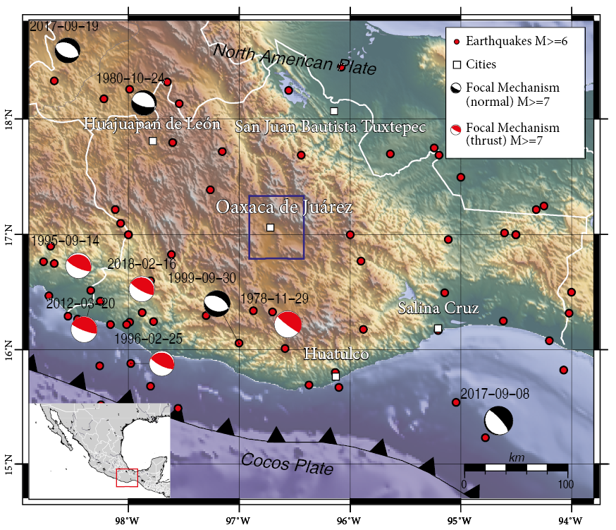
Figure 1. Seismicity with magnitude greater than 6Mw in the state of Oaxaca, Mexico from 1910 to 2024 (reported by the "Servicio Sismológico Nacional", www.ssn.unam.mx). Focal mechanism for earthquakes with M>7 reported by Global CMT Catalog (www.globalcmt.org) for the period 1976-2024 (Dziewonski et al., 1981; Ekström et al., 2012). The study area is presented in the blue square.
Local site effects due to soft sediments can play a significant role in the amplification of seismic wave ground motions during earthquakes (Aki, 1993). There is, therefore, ample need to carry out a comprehensive seismic microzonation of Oaxaca City to provide the seismic parameters for any future socio-economic applications, such as civil protection, construction guidelines, local regulations, building optimization, and urbanization (Zavala et al., 2021), as well as the importance of carrying out local micro-zoning studies in areas of world heritage buildings (García-Nieto et al., 2021).
STUDY AREA
Oaxaca is one the most active seismic zones in southern Mexico, concentrating up to 28 % of the seismicity reported by the SSN throughout Mexico (SSN, 2024). It also comprises the seismic activity related to intraplate structures, causing shallow quakes associated with the Oaxaca fault system, which is formed at the borders between the Zapoteco (Oaxaca) and Cuicateco (Juárez) terranes, and besides its normal component has always been thought to have a horizontal component in arguable direction (Campa & Coney, 1983; Sedlock et al., 1993; Alaniz-Álvarez et al., 1994; Garduño-Monroy et al., 2019).
This tectonic environment belongs to the following seismotectonic regions: 1) NAM, a zone of intraplate events (depth h <20 km) that take place on the continental plate southeast of Mexico, and 2) seismogenic region IN2, which is a transition zone of the Cocos plate, with intermediate-depth intraplate events (40 km <h <255 km). Zúñiga et al. (2017) estimated recurrence periods for the central zone of the State of Oaxaca of 6 years for earthquakes with magnitudes greater than 5 that occur in the NAM zone, periods of 109 years for magnitudes greater than 7 that occur within the Cocos plate subduction, and periods of 37 years for earthquakes of magnitude greater than 7.5 occurring in the coupling zone of the Cocos and North American tectonic plates (SUB3).
The most important events recorded for this area are:
- February 3, 1911: Huajuapan de León, Oax., Mw6.5, depth 80 km (SSN-Catálogo de sismos grandes, 2024; Intra-plate event, Cocos plate, normal faulting)
- February 9, 1928: Acatlán de Osorio Pue., Mw6.5, depth 84 km (SSN-Catálogo de sismos grandes, 2024; Intra-plate event, Cocos plate, normal faulting)
- January 14, 1931: Miahuatlán, Oax., Mw7.8, depth 40 km (Singh et al., 1985; Intra-plate event, Cocos plate, normal faulting)
- July 25, 1937: Veracruz border, Mw7.3, depth 85 km (SSN-Catálogo de sismos grandes, 2024 and Nava, 1998; Intra-plate event, Cocos plate, normal faulting)
- August 28, 1973: Veracruz border, Mw7.3, depth 82 km (SSN-Catálogo de sismos grandes, 2024; Intra-plate event, Cocos plate, normal faulting)
- October 24, 1980: Acatlán de Osorio Pue., Mw7.1, depth 65 km (SSN-Catálogo de sismos grandes, 2024; Intra-plate event, Cocos plate, normal faulting)
- February 2, 1998: San Pedro Pochutla, Oax., Mw6.4, depth 33 km (SSN, 2023 and Solano-Hernández & Mendoza-Ponce, 2021; Strong coupling subduction event, thrust faulting)
- September 30, 1999: Puerto Escondido, Oax., Mw7.4, depth 39km (Singh et al., 2000; Intra-plate event, Cocos plate, normal faulting)
- March 20, 2012: Pinotepa Nacional region, Mw7.5, depth 18km (UNAM Seismology Group, 2013; Strong coupling subduction event, thrust faulting)
- September 7, 2017: Tehuantepec Isthmus region, Mw8.2, depth 45 km (Melgar et al., 2018; Intra-plate event, Cocos plate, normal faulting)
- February 16, 2018: Pinotepa Nacional, Oax., Mw7.2, depth 16 km (Fielding et al., 2022; Strong coupling subduction event, thrust faulting)
- and June 23, 2020: Huatulco, Oax., Mw7.4, depth 22 km (Velazquez-Bucio et al., 2023; Strong coupling subduction event, thrust faulting).
The city of Oaxaca de Juárez is one of Mexico’s most representative cities, both in terms of tourism and culture. It is located in the central portion of the state of the same name and covers an area of 63,786 hectares (637 km2). Made up of 26 municipalities (See Figure 2), the city lies at the junction of the valley of Etla to the north, the valley of Tlacolula-Mitla to the southeast and the valley of Zaachila-Zimatlán to the south (Marcus & Flannery, 1994; Piperno & Flannery, 2001). The Sierra de Juárez bounds the study area to the east and the Sierra de Oaxaca to the west.
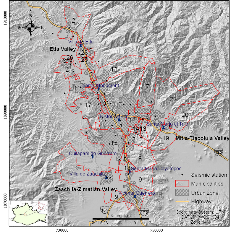
Figure 2. Map of the 26 municipalities of the metropolitan area of Oaxaca (ZMO). Source: prepared based on data obtained from the INEGI (2023).
Figure 2 shows the 26 municipalities that make up the ZMO and that correspond to: 1. Ánimas Trujano, 2. Magdalena Apasco, 3. Nazareno Etla, 4. Oaxaca de Juárez, 5. San Agustín de las Juntas, 6. San Agustín Yatareni, 7. San Andrés Huayapam, 8. San Antonio de la Cal, 9. San Bartolo Coyotepec, 10. San Jacinto Amilpas, 11. San Lorenzo Cacaotepec, 12. San Pablo Etla, 13. San Sebastián Tutla, 14. Santa Cruz Amilpas, 15. Santa Cruz Xoxocotlán, 16. Santa Lucía del Camino, 17. Santa María Atzompa, 18. Santa María Coyotepec, 19. Santa María del Tule, 20. Santo Domingo Tomaltepec, 21. Soledad Etla, 22. Tlalixtac de Cabrera, 23. Villa de Etla, 24. Villa de Zaachila, 25 Guadalupe Etla and 26. San Andres Zautla.
SURFICIAL GEOLOGY
Oaxaca City is located in the geological province of the Sierra Madre del Sur (SMS), which presents different basement terranes with contrasting stratigraphy and tectonic features (Ortega-Gutierrez, 1981; Campa & Coney, 1983; Morán-Zenteno, 1999). The Central Valley region comprises the Zapoteco (Oaxaca) and Cuicateco (Juárez) terranes (Campa & Coney, 1983; Sedlock et al., 1993).
The Zapoteco terrane is composed of a basement of Precambrian rocks, i.e., Oaxaca Complex rocks (Fries et al., 1962), covered by non-continuous and non-metamorphed Paleozoic sedimentary rocks (Sedlock et al., 1993). The Oaxaca complex is the oldest basement in southern Mexico and is made up of a series of paragneisses and orthogneisses, meta-anorthosites, calc-silicate metamorphic rocks, and charnockites. Intrusive granite from the Tertiary is the rock with the smallest distribution in the area, since it is only observed in two small areas to the north and northeast. The Suchilquitongo formation is exposed in the northern area between Oaxaca and Etla. It is mainly constituted of ignimbrite, polymictic conglomerate, andesitic tuff, sandstone, and lake limestone. The volcaniclastic units sometimes present intercalations of lake and river sediments, in addition to being frequently affected by hypabyssal intrusions of variable composition. The ages obtained by Ferrusquía-Villafranca and McDowell (1991) in four different zones of the central and southeastern parts of Oaxaca vary from 20.6 to 13.5 Ma. Fluvial sediments of the Tertiary and Quaternary ages predominate in the Valley, resulting from cyclical accumulation-erosion changes.
The Cuicateco terrane sequence defines a belt of folds and NNWO – SSE ridges with vergence to the east, whose origin has been attributed to the Laramide orogeny during the Late Cretaceous-Early Tertiary (Carfantan, 1985; Delgado-Argote, 1989; Barboza-Gudiño and Schwab, 1996; Ángeles-Moreno, 2006). The youngest tectonic events are characterized by a brittle deformation defined by Eocene-Miocene lateral and normal faults (Carfantan, 1985; Ángeles-Moreno, 2006). The Mylonitic complex has been interpreted as a thrust zone reactivated in the Jurassic, followed by normal brittle-ductile fault reactivation during the Cenozoic uplift of the mylonitic belt (Delgado-Argote, 1989; Centeno-García et al., 1990; Alaniz-Alvarez et al., 1996), and also interpreted as the juxtaposition zone of the Zapoteco and Cuicateco terranes (Centeno-García et al., 1990), which gives it a saddle-like geometry directed towards the east. The youngest rocks, a polymictic conglomerate and alluvial deposits, product of the erosion of pre-existing rocks, are located in the southern portion of the area.
In the mountains, the soil mosaic is made up of poorly developed soils such as Leptosols, to highly developed Acrisols. The Acrisols are located on Tertiary rocks (tuffs of andesitic composition) in the eastern part of the sierras and mountains of the districts of Tlalixac de Cabrera and Santo Domingo Tomaltepec. In the mountains of the Sierra Juárez, Cambisols predominate over the mylonitic complex and sandstones. Luvisols predominate in the center and south of the area in Requemontes, as different types of igneous, sedimentary, and metamorphic rocks; to the southwest, they predominate in mountain ranges and mountains. Regosols are located in foothills, and to a lesser extent in low and high hills; Phaeozems are associated with piedmont, valley, and plain, and sedimentary-type rocks; Leptosols are mostly associated with low slopes that develop on sedimentary rocks and tuffs; and Fluvisols are young soils associated with slopes of less than 5 % and alluvial deposits located in the valley zone.
In particular, in the northern zone of the ZMO, sediments of different sizes such as clays, sand, gravel and boulders are found in the form of a heterogeneous mixture (Belmonte-Jiménez et al., 2003).
HVSR MICROTREMOR DATA ANALYSIS
Nakamura’s method (Nakamura, 1989; 2000) is used to estimate the site response characteristics, both of the fundamental frequency of the soil and of the amplification. The method measures environmental noise using three-components seismometers and estimates the resonance frequency. As a result, the transfer function at a specific site (TF) is expressed by the spectral ratio between the horizontal and the vertical components of the ambient noise measured in that particular site (H/V). H is usually considered as the average of the spectra in the horizontal plane. Resonance frequencies are inversely proportional to the depths of high impedance contrasts and can be interpreted to ascertain the thickness of unconsolidated sediments (Nakamura, 1989).
The Horizontal to Vertical Spectral Ratio (HVSR) technique is one of the cheapest and simplest geophysical tools in terms of data acquisition and processing (Mucciarelli, 2003). For these reasons, it has been used in different regions all over the world, such as Italy (e.g. Cara et al., 2008; Massa et al., 2009), Spain (e.g. Cadet et al., 2011; López Casado et al., 2018), and Mexico (Chávez-García & Tejeda-Jácome, 2010; Zavala et al., 2021; Cortez et al., 2023). The HVSR technique is a passive seismic method used to determine the resonance frequency and amplification of ground motions influenced by a surface layer. In earthquake engineering, HVSR data is important in the seismic hazard microzonation and local site effect studies. It was proposed by Nogoshi and Igarashi (1971) and by Nakamura (1980).
A great advantage of this methodology is that the soil response can be investigated using only one single station (Delgado et al., 2000a; 2000b; Clemente-Chávez et al., 2014), which is useful in the field of geotechnical earthquake engineering (SESAME, 2005). While other techniques are not applicable due to the high cost or their invasive nature, this approach is widely used in the development of seismic hazard microzonation maps in densely-populated metropolitan areas, as referred above. Moreover, the HVSR method has recently been used to estimate the natural frequency (or structural period) of buildings with different heights and construction systems, also proving to be a useful application to determine the soil-structure interaction (Stanko et al., 2017).
Particularly, in the area of the municipality of Oaxaca de Juárez, Lermo-Samaniego-Samaniego and Chávez-García (1995) installed a network of short-period seismographs (1 second of natural period), covering 20 sites in areas of sedimentary deposits within the municipality through the Nakamura (1989) technique. Lermo-Samaniego and Chávez-García (1995) obtained dominant periods in the order of 0.25 to 0.8 seconds in the city.
SEISMIC DATA ACQUISITION
In the present case, microtremor measurements were performed at 57 selected sites (see Table 1) in the ZMO (Figure 3a) in order to estimate the empirical transfer function, applying the Nakamura technique and considering the recommendations established by SESAME (2005) . Our selection of the sites was performed contemplating the various soil types along the studied area.
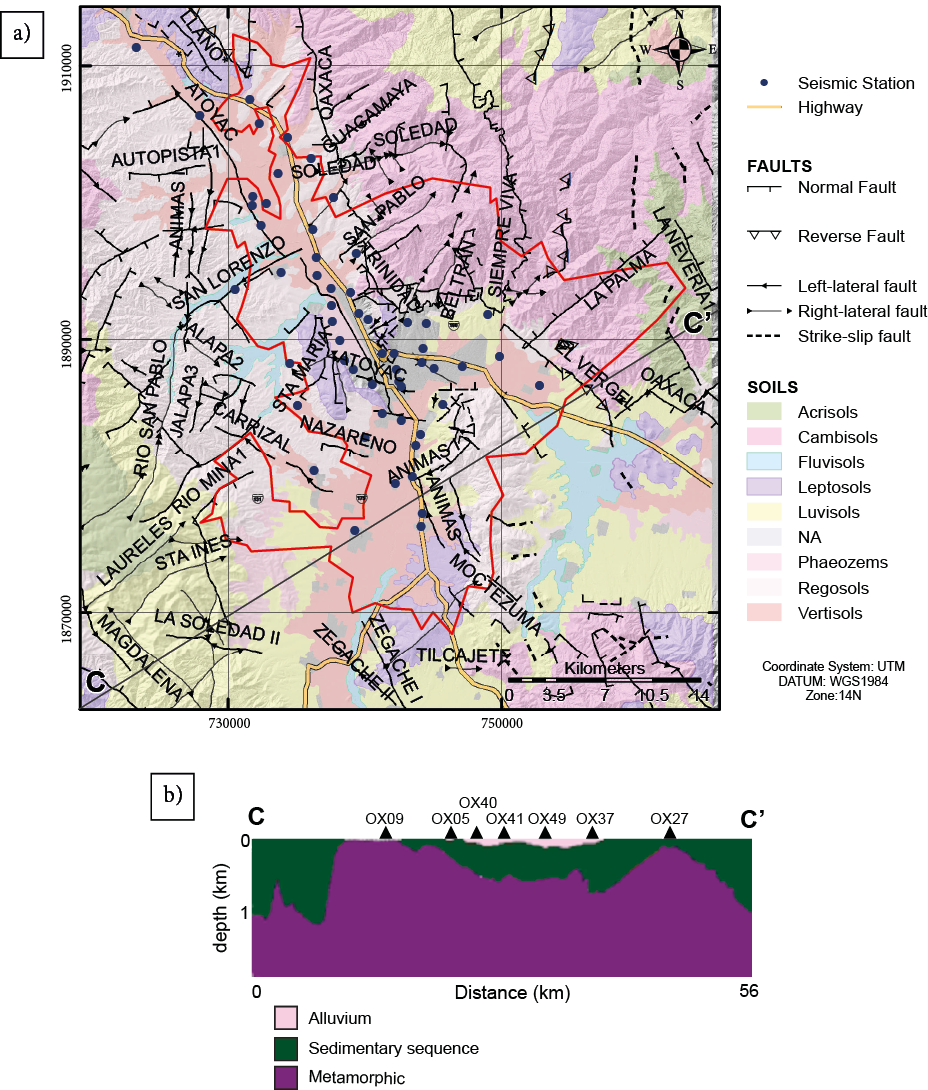
Figure 3. a) Distribution of stations is shown with respect to the predominant types of soils and the structural faults in the studied area. b) Geological profile along the Section C-C’ (modified from Hernández-Sánchez, 2016).
Table 1. Geographic coordinates for the measured microtremor sites. Coordinate system: UTM Zone 14N.
|
Point |
Reference |
Longitude |
Latitude |
|
OX01 |
Trinidad de Viguera |
737533.55 |
1893756.33 |
|
OX02 |
Héroes de Chapultepec |
742142.24 |
1888969.31 |
|
OX03 |
Forestal Suburb, Sta. María Aztompa |
737644.81 |
1891360.50 |
|
OX04 |
Plazuela de San Juanito |
740573.17 |
1886743.91 |
|
OX05 |
La Raya |
742248.00 |
1879500.00 |
|
OX06 |
5 de mayo |
742317.99 |
1887861.24 |
|
OX07 |
IPN - CIDIIR Unidad Oaxaca |
742698.92 |
1884109.84 |
|
OX08 |
Insurgentes Xoxocotlán Suburb |
741292.55 |
1884660.67 |
|
OX09 |
Zaachila, El niño |
739292.93 |
1876028.94 |
|
OX10 |
San José la Noria Suburb |
742684.31 |
1886640.14 |
|
OX11 |
UGM |
736472.05 |
1895992.04 |
|
OX12 |
San Felipe Tejalapam |
730518.56 |
1893684.90 |
|
OX13 |
San Lorenzo |
733887.83 |
1894922.65 |
|
OX14 |
Santo Domingo Barrio Bajo |
733655.28 |
1902161.03 |
|
OX15 |
San Pedro Ixtlahuaca |
734507.84 |
1888303.33 |
|
OX16 |
San Jerónimo Yahuiche |
737566.01 |
1892532.13 |
|
OX17 |
San Martín Suburb |
739171.76 |
1887800.75 |
|
OX18 |
Colinas de Monte Albán |
738523.51 |
1888462.99 |
|
OX19 |
Pueblo Nuevo |
738955.32 |
1893479.20 |
|
OX20 |
Santiaguito Etla |
736205.68 |
1898099.79 |
|
OX21 |
Magdalena |
731599.98 |
1907581.99 |
|
OX23 |
Santa Rosa |
739587.14 |
1891898.11 |
|
OX24 |
Lomas de Santa Rosa |
740235.61 |
1891497.20 |
|
OX25 |
Esmeralda |
736528.69 |
1894734.80 |
|
OX26 |
Santa Lucía |
745061.81 |
1887913.58 |
|
OX27 |
Santa Maria El Tule |
752809.25 |
1886664.93 |
|
OX28 |
Viguera-San Pablo |
739383.57 |
1896316.49 |
|
OX29 |
La Asunción |
734348.40 |
1904820.83 |
|
OX30 |
Benito Juárez Monument |
747148.44 |
1888105.04 |
|
OX31 |
Cuilapam |
736294.69 |
1880458.27 |
|
OX32 |
Huayapam |
749020.15 |
1891854.30 |
|
OX33 |
Volcanes |
744497.51 |
1891230.27 |
|
OX34 |
San Felipe Suburb |
743130.07 |
1891262.79 |
|
OX35 |
Arrazola Town |
735100.74 |
1885225.37 |
|
OX36 |
San Agustín |
743747.57 |
1882314.46 |
|
OX37 |
San Bartolo Coyotepec |
744124.56 |
1876374.75 |
|
OX38 |
Nazareno Etla |
731815.00 |
1900495.00 |
|
OX39 |
Soledad Etla |
731770.00 |
1899838.00 |
|
OX40 |
Ánimas Trujano |
743468.00 |
1879986.00 |
|
OX41 |
Tlalixtac |
749874.00 |
1888742.00 |
|
OX42 |
Guadalupe Etla |
732789.00 |
1899989.00 |
|
OX43 |
Matadamas Etla |
732419.00 |
1898366.00 |
|
OX44 |
Villa de Etla |
723292.00 |
1911380.00 |
|
OX45 |
San Agustín Etla |
737738.00 |
1900386.00 |
|
OX46 |
Lachixolana |
727937.67 |
1906412.39 |
|
OX47 |
Catano Suburb |
732291.00 |
1905812.00 |
|
OX48 |
San Miguel Etla |
736067.00 |
1903290.00 |
|
OX49 |
Santa María Coyotepec |
744202.00 |
1877318.00 |
|
OX50 |
San Antonio de la Cal |
744101.00 |
1883097.00 |
|
OX51 |
La Noria Suburb |
742510.27 |
1886991.30 |
|
OX52 |
Oaxaca Cultural Center |
744196.27 |
1888372.46 |
|
OX53 |
Las Flores Suburb |
744277.94 |
1889396.23 |
|
OX54 |
El Rosario Suburb |
1885300.48 |
1885300.48 |
|
OX55 |
Santa Cruz Xoxocotlán |
1882852.00 |
740014.79 |
|
OX56 |
Oaxaca suburb |
1889973.00 |
738187.00 |
|
OXIG |
OXIG National Seismological Service |
741276.90 |
1888982.60 |
Measurements have been conducted through the implementation of a portable seismic station equipped with a three-component velocity sensor (Trillium Compact 120s broadband seismometer) connected to a three-channel DataCUBE data logger (sampling rate of 200 samples per second).
We followed the recommendations of the Centro Nacional de Prevención de Desastres (CENAPRED) for seismic microzonation studies to allow data acquisition in the frequency bandwidth [0.1,10] Hz (CENAPRED, 2017). A GPS receiver was connected to the data logger in order to provide the location coordinates and confirm the time frame for each measurement. Each seismic measurement was preferably carried out at night when the level of anthropogenic noise is lower. We have ensured that the data acquisition has a minimum duration of 4 hours to ensure that the sensor has stabilized, and the measurement is not disturbed by temperature (Zavala et al., 2021). and considering seismic records with a sample rate of 200 sps. The broadband equipment was placed on the ground with a thermal insulation system. Figure 3 shows the geographical distribution of the measured sites in relation to the different soils units and the structural faults in the studied area. Also shown is a 73km-long geological profile with SW-NE direction, obtained from Hernández-Sánchez (2016) through inversions of magnetometric and gravimetric data. The predominant geological units are (a) metamorphic rocks (gneiss and anorthosite), belonging to the Oaxacan complex and the Aloapan Mylonitic complex (andesitic-andesite tuff); (b) sedimentary rock (Jaltepetongo) and volcanic rocks (Suchilquitongo); and (c) alluvium unit (Campos-Enriquez et al., 2010; Hernández-Sánchez, 2016).
The Nakamura technique allowed to obtain the fundamental frequency and period values for each of the sites. The behavior of the data obtained from the mean spectral ratios graphs allowed us to classify three predominant behaviors in the study area (Figure 4).
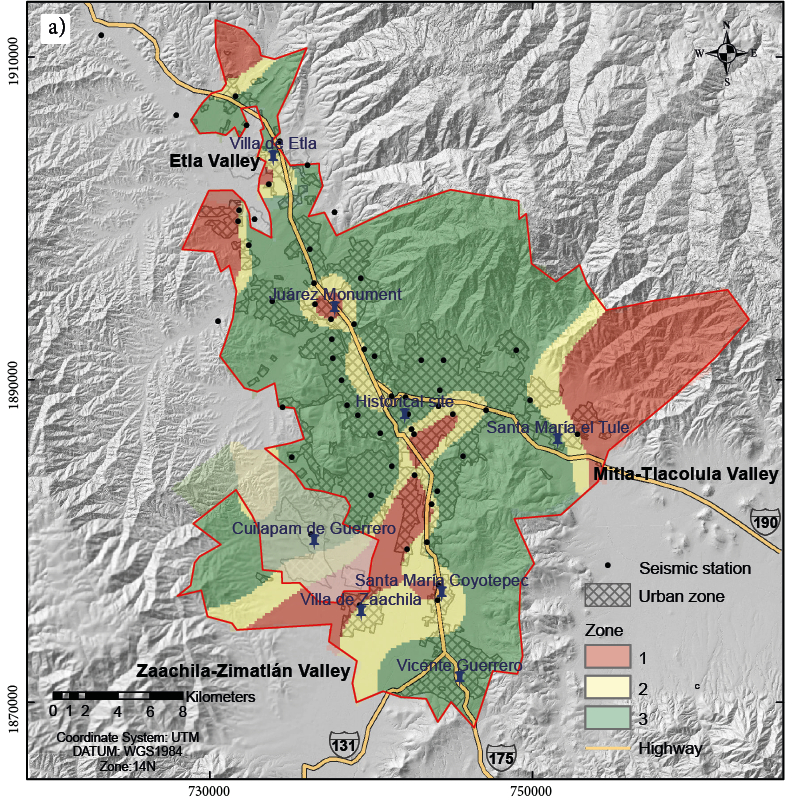
Figure 4. a) Map of seismic zones in the ZMO. b) Mean spectral ratios H/V for each zone: red (zone 1), yellow (zone 2), and green (zone 3). Continues.
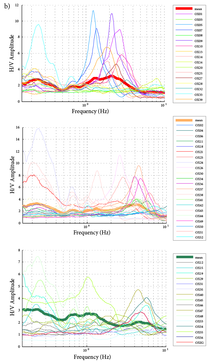
Figure 4 (cont.). a) Map of seismic zones in the ZMO. b) Mean spectral ratios H/V for each zone: red (zone 1), yellow (zone 2), and green (zone 3).
MAP OF SEISMIC SITE CLASSES
The first seismic microzonation map for the metropolitan area of Oaxaca (ZMO) was obtained by applying the geostatistical method of ordinary kriging interpolation (Figure 4) based on ambient noise recorded on broadband seismometers.
The results show characteristic frequencies of the soil that vary from 0.1 to 10 Hz. The highest frequency values (low periods) correspond to metamorphosed rocks, such as gneiss and the metamorphic complex. This area of low periods is observable in the direction of the mountains and north of the City of Oaxaca. The intermediate zone covers periods of 0.22 to 1.3 s, the latter related to soils of the Regosol and Vertisol type in transition zones from the plains to the foothills. The lower zone encompasses dominant periods greater than 1.3s, which correspond to fluvial deposits that increase in thickness towards the south.
In addition, zone 1 is associated with the prevalence of Vertisols and Luvisols, which prevail in the lower areas of the valley. Zone 2 corresponds to transition zones, which mostly predominate in foothills and low hills. Zone 3 is related to high areas, such as hills and mountains. The prevailing soils are Regosols and Leptosols. In Figure 4b, we can observe the classification of the mean HVSR spectral ratios for each family identified in Figure 4a.
CONCLUSIONS AND DISCUSSIONS
This work presents a first seismic classification map for building purposes in the Oaxaca Metropolitan Area (ZMO) through HVSR calculation. It also features a correlation with the geology and the soil in order to estimate the distribution of materials susceptible to ground shaking amplification, as we can see in Figure 5, where the different periods obtained for the ZMO and soil types can be identified. A classification of the HVSR for different lithologic units outcropping in Oaxaca City (silts, alluvium, conglomerates, shales, and limestones) has been integrated for the first time.
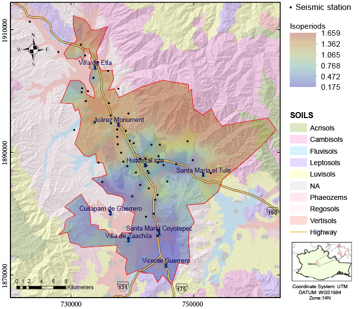
Figure 5. Summary map of results. The data of the isoperiods are presented as well as the types of soil present in the ZMO.
Usually, the younger and softer soils amplify ground motion more than older and better consolidated soils or bedrock. As observed in Figure 4a, in the central zone of the Oaxaca Metropolitan Area valley, the seismic site response is greater than in the mountains. However, compared to the Etla valley, the Zaachila-Zimatlán and Mitla-Tlacolula valleys are more vulnerable to the site effects.
As a comparison, the isoperiod data obtained for the municipality of Oaxaca de Juaréz are consistent with those obtained in the periphery of the city of Oaxaca (Lermo-Samaniego & Chávez-García, 1995), once the seismic records coincide with areas of sedimentary deposits (periods between 0.4sec – 0.6sec).
However, in this work it is possible to identify an area with periods in the order of 1 second in a zone with a NE-SW trend (Figure 6). This area corresponds to the area of historical monuments of the city of Oaxaca. This trend is also present in the previous study by Lermo-Samaniego and Chávez-García (1995) although the periods seem to be underestimated. This discrepancy may be due to the limitations of the measurement equipment used in previous studies compared to broadband equipment, as we observed in previous comparisons in the City of Querétaro (Zavala et al., 2021).
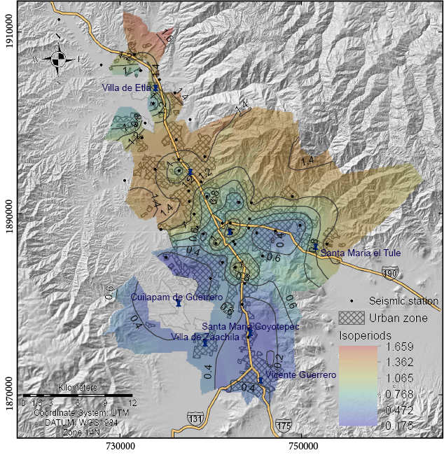
Figure 6. Seismic microzonation in the metropolitan area of Oaxaca, Mexico, based on the ordinary Kriging geoestatical interpolation.
Therefore, the local effect depends on variables such as topography, surface layers, and the characteristics of the earthquake (Figure 5). The knowledge of the dominant periods of the soil, as well as their distribution, is very useful to estimate their coincidence with the natural periods of buildings and civil structures.
Acknowledgements
We want to thank the local government and the communities of the Oaxaca Metropolitan Area for all the help provided. All the information relating to historical earthquakes in the State of Oaxaca was provided by the SSN, whose personnel also carried out the seismic stations set up, maintenance, and data acquisition. Some of the figures were drawn with the help of The Generic Mapping Tools (Wessel and Smith, 1991). Copy-edited by Ambar Geerts Zapién. Constructive reviews by
Dra. Claudia Quinteros and an anonymous reviewer helped to improve the manuscript.
Funding
This project was carried out with geophysical and computer equipment from the GEMex PT5.2 “Sísmica” project and with support from “Convocatoria 2023 de Apoyos Complementarios para estancias Sabáticas Vinculadas a la Consolidación de Grupos de Investigación” from CONAHCYT. M.M.L. received support of of CONAHCyT (scholarship number 1006468) to carry out MSc studies at INICIT-UMSNH.
Author Contributions
Conceptualization, A.F.S., A.M.P., and M.M.L.; Methodology, A.F.S. and E.L.G.; Validation, A.F.S, S.I.B.J and R.I.H.S; Writing—original draft, A.F.S. and M.M.L.; Writing—review & editing, J.A.A.O., E.L.G. and A.F.S.; Visualization, M.M.L. and A.M.P.; Supervision, A.F.S. and R.I.H.S. All authors have read and agreed to the published version of the manuscript.
Data Availability Statement
Data available on request from the authors. The data that support the findings of this study are available from the corresponding author upon reasonable request.
Conflicts of Interest
The authors declare no conflicts of interest.
REFERENCES
Aki, K. (1993). Local site effects on weak and strong ground motion. Tectonophysics, 218(1-3), 93–111. https://doi.org/10.1016/0040-1951(93)90262- I
Alaniz-Alvarez, S., van der Heyden, P., Nieto Samaniego, A. F., & Ortega-Gutiérrez, F. (1996). Radiometric and kinematic evidence for Middle Jurassic strike-slip faulting in southern Mexico related to the opening of the Gulf of Mexico. Geology, 24(5), 443–446. https://doi.org/10.1130/0091-7613(1996)024<0443:RAKEFM>2.3.CO;2
Alaniz-Álvarez, S. A., Ortega-Gutiérrez, F. O., & Nieto-Samaniego, Á. F. (1994). Structural evolution of the Sierra de Juárez mylonitic complex, State of Oaxaca, Mexico: Revista Mexicana de Ciencias Geológicas, 11(2), 147–156.
Ángeles-Moreno, E. (2006). Petrografía, geología estructural y geocronología del borde noroccidental del terreno Cuicateco, Sierra Mazateca, estado de Oaxaca, México[MSc. Thesis]. Universidad Nacional Autónoma de México, Posgrado en Ciencias de la Tierra.
Barboza-Gudiño, J. R., & Schwab, K. (1996). Contribución a la geología de la Sierra de Juárez en el sur de México: Zentralblatt für Geologie und Paläontologie. Teil, 1(1994), 991-1005.
Belmonte-Jiménez, S. I., Campos-Enríquez, J. O., & Herrera-Barrientos, J. (2003). Determinación de la vulnerabilidad del acuífero del Valle de Etla, Oaxaca, México. Revista Geofísica, (59), Retrieved from https://revistasipgh.org/index.php/regeofi/article/view/564
Cadet, H., Macau, A., Benjumea, B., Bellmunt, F., & Figueras, S. (2011). From ambient noise recordings to site effect assessment: The case study of Barcelona microzonation. Soil Dynamics and Earthquake Engineering, 31(3), 271–281. https://doi.org/10.1016/j.soildyn.2010.07.005
Campa, M. F., & Coney, P. J. (1983). Tectono-stratigraphic terranes and mineral resource distributions in Mexico. Canadian Journal of Earth Sciences, 20(6), 1040–1051. https://doi.org/10.1139/e83-094
Campos-Enriquez, J. O., Belmonte, S. I., Keppie, J. D., Ortega, F., Arzate, J. A., Martínez, J., & Martínez-Serrano, R. G. (2010). Gravity and magnetic survey of the Oaxaca city region: Cenozoic horst-and-graben structure superimposed on the Oaxaca-Juárez terrane boundary, southern Mexico. Journal of South American Earth Sciences, 29(3), 572–585.
Cara, F., Cultrera, G., Azzara, R. M., De Rubeis, V., Di Giulio, G., Giammarinaro, M. S., & Rovelli, A., (2008) Microtremor measurements in the city of PaLermo-Samaniego, Italy: Analysis of the correlation between local geology and damage. Bulletin of the Seismological Society of America, 98(3), 1354-1372. https://doi.org/10.1785/0120060260
Carfantan, J. Ch. (1985). Du Systeme Cordilleran nord–american au domaine Caraibe. Etude Geologique du Mexique Meridional [Mémoire de Thése de Docteur d'Etat]. Université de Savoie.
CENAPRED (2017). Metodología para realizar estudios de Microzonificación Sísmica. Secretaría de Gobernación, Centro Nacional de Prevención de Desastres, Dirección de Investigación, Subdirección de Riesgos Sísmicos, Jefatura de Investigación Aplicada a Riesgos Sísmicos.
Centeno-García, E., Ortega-Gutiérrez, F., & Corona-Esquivel, R. (1990). Oaxaca Fault: Cenozoic reactivation of the suture between the Zapoteco and Cuicateco terranes, Southern Mexico. Geological Society of America, Cordilleran Section Meeting, Abstracts with Programs, 13.
Chávez-García, F. J., & Tejeda-Jácome, J. (2010). Site response in Tecomán, Colima, Mexico—I: Comparison of results from different instruments and analysis techniques. Soil Dynamics and Earthquake Engineering, 30(8), 711–716. https://doi.org/10.1016/j.soildyn.2010.03.001
Clemente-Chavez, A., Zúñiga, F. R., Lermo-Samaniego, J., Figueroa-Soto, A., Valdés, C., Montiel, M., & Chávez, O., Arroyo, M. (2014). On the behavior of site effects in central Mexico (the Mexican volcanic belt–MVB), based on records of shallow earthquakes that occurred in the zone between 1998 and 2011. Natural Hazards and Earth System Sciences, 14(6), 1391–1406, https://doi.org/10.5194/nhess-14-1391-2014
Cortez, S. A., Velasco, A. A., Karplus, M. S., Dena Ornelas, O. S., Gonzalez‐Huizar, H., Pérez‐Campos, X., & Pant, M. (2023). H/V Analysis in Juchitán de Zaragoza, Oaxaca, Following the 2017 M 8.2 Tehuantepec, México, Earthquake. Bulletin of the Seismological Society of America, 113(2), 804–822, https://doi.org/10.1785/0120210141
Delgado, J., Lopez Casado, C, Giner, J., Estévez, Α., Cuenca, Α., & Molina, S. (2000a). Microtremors as a Geophysical Exploration Tool: Application and Limitations. Pure Applied Geophysics, 158, 2525–2541.
Delgado, J., Lopez Casado, C, Estévez, Α., Giner, J., Cuenca, Α., & Molina, S. (2000b). Mapping soft soils in the Segura river valley (SE Spain): a case study of microtremors as a exploration tool: Journal of Applied Geophysics, 45, 19–32.
Delgado-Argote, L. A. (1989). Volcanosedimentary Cuicateco Terrane, Oaxaca, Mexico. Geofísica Internacional, 28(5), 939–973.
Dziewonski, A. M., Chou, T. A., Woodhouse. J. H. (1981). Determination of earthquake source parameters from waveform data for studies of global and regional seismicity. Journal of Geophysical Research, 86, 2825–2852. doi:10.1029/JB086iB04p02825
Ekström, G., Nettles, M., & Dziewonski, A. M. (2012). The global CMT project 2004-2010: Centroid-moment tensors for 13,017 earthquakes. Physics of the Earth and Planetary Interiors, 200-201, 1–9. doi:10.1016/j.pepi.2012.04.002.
Ferrusquía-Villafranca, I., McDowell, F. W. (1991). The Cenozoic sequence of selected areas in Southeastern Mexico, its bearing in understanding regional basin development there. Memoria, II Convención sobre la evolución geológica de México, Pachuca, Hidalgo, 1, 45-50.
Fielding, E., Gonzalez-Ortega, J. A., Gombert, B., Duputel, Z., Liang, C., Bekaert, D., & Ampuero, J. P., (2022). The February 2018 Mw 7.2 Pinotepa earthquake in Mexico ruptured a small patch of the Oaxaca megathrust. Auth orea Preprints. https://doi.org/10.1002/essoar.10500290.2
Fries, C., Jr., Schmitter, E., Damon, P. E., & Livingston, D. E. (1962). Rocas precámbricas de edad grenvilliana de la parte central de Oaxaca en el sur de México. Universidad Nacional Autónoma de México, Inst. Geología, Boletín, 64, 45–53.
García-Nieto, M., Martínez-Segura, M., Navarro, M., & Alarcón, P. (2021). Seismic Microzonation: A Preventive Measure for the Conservation of the Built Heritage. In F. F. Arefian, J. Ryser, A. Hopkins, J. Mackee, (Eds), Historic Cities in the Face of Disasters, The Urban Book Series (pp 523–541). Springer, Cham. https://doi.org/10.1007/978-3-030-77356-4_31
Garduño-Monroy. V. H., Figueroa-Soto. A., Magaña-García, N., Ruiz-Figueroa, A., Gómez-Cortés, J., Jiménez-Haro, A., & Hernández-Madrigal, V. M. (2019). "The Mitla Landslide, an Event That Changed the Fate of a Mixteco/Zapoteco Civilization in Mesoamerica". International Journal of Geophysics, 2019, Article ID 5438381, 14 pages. https://doi.org/10.1155/2019/5438381
Hernández-Sánchez, R. I. (2016). Prospección de aguas subterráneas en los valles centrales de Oaxaca a partir de los métodos geofísicos de gravimetría, magnetometría y resistividad eléctrica [MsC Thesis]. Instituto Politécnico Nacional, Centro interdisciplinario de Investigación para el Desarrollo Integral Regional Unidad Oaxaca. http://literatura.ciidiroaxaca.ipn.mx:8080/xmlui/handle/LITER_CIIDIROAX/265
INEGI (2023). Continuo de Elevaciones Mexicano (CEM) and Sistema de Consulta. Instituto Nacional de Estadística y Geografía, https://www.inegi.org.mx/temas/, (accessed February 2024).
Juan de Córdova (1578). Vocabulario en Lengua Zapoteca. México, Pedro Charte y Antonio Ricardo. ISBN: 978-607-02-8307-9. Project by Dr. Michel Oudijk, Instituto de Investigaciones Filológicas, UNAM. https://www.iifilologicas.unam.mx/cordova/
Lermo-Samaniego-Samaniego, J., & Chávez-García, F. (1995). Efectos de sitio en la Ciudad de Oaxaca. Resultados con registros de temblores y mediciones de microtremores. Revista de Ingeniería Sísmica, 50, 1–13.
López Casado, C., Garrido, J., Delgado, J., Peláez, J. A., & Henares, J. (2018). HVSR estimation of site effects in Melilla (Spain) and the damage pattern from the 01/25/2016 Mw 6.3 Alborán Sea earthquake. Natural Hazards, 93, 153–167. https://doi.org/10.1007/s11069-017-3132-8
Marcus, J., & Flannery, K. V. (1994). Ancient Zapotec ritual and religion: an application of the direct historical approach. The ancient mind: elements of cognitive archaeology, 55–74.
Massa, M., Lovati, S., Di Giacomo, D., Marzorati, S., D'Alema, E. & Augliera, P. (2009) A Microtremor Survey in the Area Shocked by the ML 5.2 Salò Earthquake (North Italy): An Empirical Approach to Determine the Effects of Ground Motions. Journal of Earthquake Engineering, 13(7), 1029–1046. https://doi.org/10.1080/13632460802663265
Melgar, D., Ruiz-Angulo, A., Garcia, E. S., Manea, M., Manea, V. C., Xu, X., Ramirez-Herrera, T., Zavala-Hidalgo, J., Geng, J., Corona, N., Pérez-Campos, X., Cabral-Cano, E., & Ramirez-Guzmán, L., (2018). Deep embrittlement and complete rupture of the lithosphere during the Mw 8.2 Tehuantepec earthquake. Nature Geoscience, 11(12), 955–960. https://doi.org/10.1038/s41561-018-0229-y
Morán-Zenteno, D. J., Tolson, G., Martınez-Serrano, R. G., Martiny, B., Schaaf, P., Silva-Romo, G., Macías-Romo, C., Alba-Aldave,L., Hernández-Bernal, M.S., & Solıs-Pichardo, G. N. (1999). Tertiary arc-magmatism of the Sierra Madre del Sur, Mexico, and its transition to the volcanic activity of the Trans-Mexican Volcanic Belt. Journal of South American Earth Sciences, 12(6), 513-535.
Mucciarelli, M., Gallipoli, M. R., & Arcieri, M. (2003). The stability of the horizontal-to-vertical spectral ratio of triggered noise and earthquake recordings. Bulletin of the Seismological Society of America, 93(3), 1407–1412. https://doi.org/10.1785/0120020213
Nakamura, Y. (2000). Clear identification of fundamental idea of Nakamura’s technique and its applications. The 12th World Conf. on Earthquake Engineering, Auckland, New Zealand, p. 2656.
Nakamura, Y. (1989). A method for dynamic characteristics estimation of subsurface using microtremore on the ground surface. Railway Technical Research Institute, Quarterly Reports, 30(1), 25–33.
Nava, A., 1998, "I. Introducción". Terremotos (9–21). Fondo de Cultura Económica, Colección La Ciencia Para Todos. ISBN 9681657683.
Nogoshi, M., & Igarashi, T. (1971). On the Amplitude Characteristics of Ambient noise (Part 2). Journal of Seismological Society Japan, 24, 26–40.
Ortega-Gutiérrez, F. (1981). Metamorphic belts of southern Mexico and their tectonic significance. Geofísica Internacional, 20(3), 177-202.
Ortega-Gutiérrez, F., Elías-Herrera, M., Reyes-Salas, M., Macias-Romo, C., & López, R. (1999). Late Ordovician-Early Silurian continental collision orogeny in southern Mexico and it's bearing on Gondwana-Laurentia connections. Geology, 27, 719–722.
Piperno, D. R., & Flannery, K. V. (2001). The earliest archaeological maize (Zea mays L.) from highland Mexico: new accelerator mass spectrometry dates and their implications. Proceedings of the National Academy of Sciences, 98(4), 2101-2103.
Sedlock, R. L., Ortega-Gutiérrez, F., & Speed, R. C. (1993). Tectonostratigraphic terranes and tectonic evolution of Mexico. Geological Society of America. https://doi.org/10.1130/SPE278-p1
SESAME Project (2003) Site Effects assessment using Ambient Excitations. http://sesame-fp5.obs.uif- qrenoble.fr. (accessed February 2024).
SESAME Project (2005). Site Effects assessment using Ambient Excitations, Recommendations for quality array measurements and processing Deliverable D24.13. http://sesame-fp5.obs.uif- qrenoble.fr. (accessed February 2024).
Singh, S. K., Ordaz, M., Alcántara, L., Shapiro, N., Kostoglodov, V., Pacheco, J. F., Alcocer, S., Gutierrez, C., Quaas, S., Mikumo, T., & Ovando, E. (2000). The Oaxaca Earthquake of 30 September 1999 (Mw= 7.5): a normal-faulting event in the subducted Cocos plate. Seismological Research Letters, 71(1), 67-78. https://doi.org/10.1785/gssrl.71.1.67
Singh, S. K., Suárez, G., & Domínguez, T. (1985). The Oaxaca, Mexico, earthquake of 1931: lithospheric normal faulting in the subducted Cocos plate. Nature, 317(6032), 56–58. https://doi.org/10.1038/317056a0
Solano-Hernández E. A., & Mendoza-Ponce, A. (2021). Sismicidad en el estado de Oaxaca de 2015 a 2019. Revista Temas, Universidad Tecnológica de la Mixteca. ISSN: ISSN 2007-0977, 25-35. https://www.utm.mx/edi_anteriores/temas75/T75_E04_sismicidad_oaxaca.pdf
SSN (2023). Reportes especiales de sismicidad. Servicio Sismológico Nacional http://www.ssn.unam.mx/sismicidad/reportes-especiales/. (accessed July 2024).
SSN (2024). Catálogo de sismos grandes. Servicio Sismológico Nacional, http://www2.ssn.unam.mx:8080/sismos-fuertes/. (accessed July 2024).
Stanko, D., Markušić, S., Strelec, S., & Gazdek, M. (2017). Equivalent-linear site response analysis on the site of the historical Trakošćan Castle, Croatia, using HVSR method. Environmental Earth Sciences, 76, 1-21. https://doi.org/10.1007/s12665-017-6971-4
UNAM Seismology group (2013). Ometepec-Pinotepa Nacional, Mexico Earthquake of 20 March 2012 (Mw 7.5): A preliminary report. Geofísica Internacional, 52(2), 173–196. https://doi.org/10.1016/S0016-7169(13)71471-5
Velázquez-Bucio, M. M., Ferrario, M. F., Muccignato, E., Porfido, S., Sridharan, A., Chunga, K., Livio, F., Gopalan, S., & Michetti, A. M., (2023). Environmental effects caused by the Mw 8.2, September 8, 2017, and Mw 7.4, June 23, 2020, Chiapas-Oaxaca (Mexico) subduction events: comparison of large intraslab and interface earthquakes. Quaternary International, 651, 62–76. https://doi.org/10.1016/j.quaint.2021.11.028
Wessel, P., & Smith, W. H. F. (1991). Free software helps map and display data. Transactions American Geophysical Union, 72(41), 445–446.
Wessel P., & Smith W. H. F. (1998). New improved version of the generic mapping tools released. EOS Trans AGU, 79(47), 579. http://dx.doi.org/10.1029/ 98EO00426
Zavala, N., Clemente-Chavez, A., Figueroa-Soto, A., González-Martínez, M., & Sawires, R. (2021). Application of horizontal to Vertical Spectral Ratio microtremor technique in the analysis of site effects and structural response of buildings in Querétaro city, Mexico. Journal of South American Earth Sciences, 103211. doi: https://doi.org/10.1016/j.jsames.2021.103211
Zúñiga, F. R., Suárez, G., Figueroa-Soto, Á., & Mendoza, A. (2017). A first-order seismotectonic regionalization of Mexico for seismic hazard and risk estimation. Journal of Seismology, 21, 1295–1322. https://doi.org/10.1007/s10950-017-9666-0
Editors:
Natalia Pardo Villaveces
Marina Manea
Copyright
© 2024 The Author(s).
This is an open-access article published and distributed by the Universidad Nacional Autónoma de México under the terms of a Creative Commons Attribution 4.0 International License (CC BY) which permits unrestricted use, distribution, and reproduction in any medium, provided the original author and source are credited.

ISSN-L 2007-2902
https://rmcg.unam.mx